


Finding a system
definition
The objective of Step 1 is to clearly define what the system in question includes (i.e. where the system has its boundaries) and its current state. This means finding out about its current challenges, determining potential solutions, and describing hazard/multi-hazard scenarios of interest. Depending on the system’s boundaries (like geographical area or the type of decision making), the risks in a system might be different and also the elements in the system.
We also identify challenges and goals of the “system owners” (those involved, stakeholders), considering things like economic effects from natural hazards in a specific area. Then, we look at different possible disaster scenarios and understand which parts of the system could be affected. We also consider how these disasters might interact, such as one causing the other or making it worse (i.e., cascading, compound, amplifying)
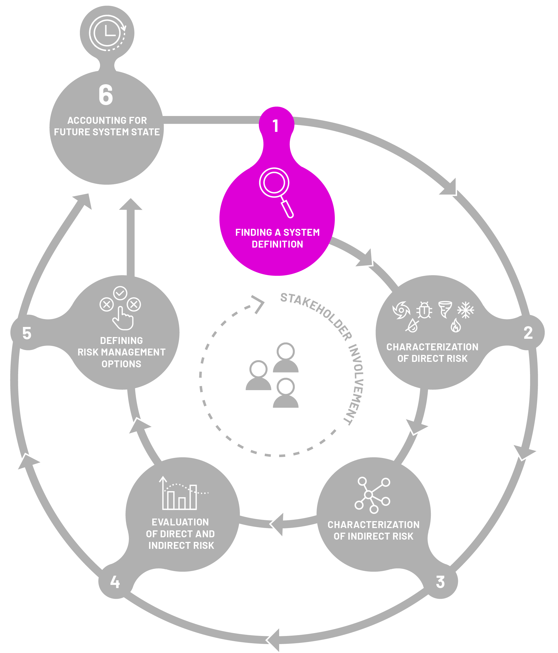
What constitues a system and
what are boundaries?
The boundaries of the system vary depending on who sets the boundaries. A homeowner household considers only its own assets such as its house, the furniture and equipment in it, etc.
An insurer considers only the assets it insures.
And a national government considers all the assets of the respective country.
In other words, a homeowner may define their system as all the assets they own, an insurer defines their system as all the assets they have insured, while the national government defines their system as all the assets of that country.
Guidance protocol questions
The following are questions that can help decision-makers, stakeholders, and relevant parties in successfully walking through step 1 of the framework. Consider this set of questions as an initial guide for your investigation, recognizing that it is not an exhaustive list.

(Initial) boundaries of the system
- What is the geographical region you are operating in/have responsibility for?
For instance, an insurance company might be operating at a national scale while the local government oversees a certain geographical area (e.g., city boundaries).
- What are the boundaries determined by policies and governance you have a responsibility for?
For instance, the agricultural department might be interested only in areas of agricultural land use, while the disaster risk management department has a remit of implementing national disaster risk management policies.
- Any specific sector of interest/focus?
Challenges and vision for the system
- What is your vision for your system (e.g., for a sector or for local government) and what are your goals?
- What are the current challenges (i.e., sustainability challenges such as spatial planning in the face of disaster risk, the resilience of tourism to multi-risk) you are experiencing in reaching this goal?
- How do natural hazards relate to these challenges/hinder you in reaching the goal?


Governance landscape and stakeholder analysis
- What are the main policies that are guiding your work?
For instance, national disaster risk management policies, local development plans, transportation, and agricultural policies.
- Who are the other main actors you are collaborating with?
For instance, the department of finance in a country might collaborate often with the department of agriculture.
Single and multi-hazards
- What are all natural hazards that impact you and/or your work/mandate/the geographical area you are in charge of?
- Do these hazards interrelate in any way? Can you provide us with some examples?
- What hazard scenarios are of interest to you?
For instance, if only considering single hazards, it might be frequent and/or more extreme flooding. If considering multi-hazards, it might be different multi-hazard scenarios (e.g., heatwaves increasing the probability of fires or earthquakes triggering landslides).


Exposure and vulnerability
- Thinking of these hazards and the areas they impact, can you identify exposed and vulnerable elements of your system?
For instance, insurance companies are insuring households and companies, and the national government is in charge of all members/components of society, therefore these are the elements exposed that will be of interest.
For vulnerability, think of it in a broader sense (e.g., the structural vulnerability of buildings, the economic vulnerability of people and companies, socially differentiated vulnerability by age, gender, and economic status).
Risk management
- What do you think is needed to reduce risk in your area/sector?
- What are the existing risk management options for the hazards of interest?
- What are good practices in the existing risk management options, and can they be built upon?
- Which management options are missing, and are there gaps? What is needed to fill these gaps?
- What is important to do for risk management in your area/sector/focus, but it is outside of your responsibility?
Note: This question might be important for delineating what is outside of the system.

