NORTH SEA

SUMMARY

The research work in the North Sea Pilot focuses on developing multi-risk pathways to manage the interrelated impacts of hazards such as storms, extreme precipitation, and marine heatwaves on  offshore renewable energy, shipping and transport, and nature sectors. This involves balancing competing sectoral objectives in spatial planning, addressing climate change risks, and promoting sustainable development and disaster risk management. The Pilot aims to enhance cooperation between countries and sectors, raise awareness of climate impacts, and integrate risk assessment into sectoral planning by developing forward-looking disaster risk management pathways together with stakeholders.

Relationship to the MYRIAD-EU Framework

Finding a system definition

The Pilot focuses on the Greater North Sea, which is a shared sea basin and large marine ecosystem, spatially planned, developed and protected by eight countries. The North Sea is a multi-use space, where both space and resources are in high demand with various  sectors, including energy producers, grid operators, oil and gas, shipping, fishing and food production all operating within the same area. In the upcoming decades major transitions are foreseen in the North Sea. These changes are driven partly by Member State’s ambitions to achieve CO2 neutrality by 2050 as outlined in the European Green Deal, and by recent geopolitical developments which have accelerated countries’ ambitions for renewable energy production. Additionally, they are influenced by the European Commission’s policy on biodiversity and nature restoration, sustainable food production, and circular economy. These ambitions create tensions between the many different users of the North Sea, as well as adding pressure to the already limited ecological space, resulting in trade-offs.


The North Sea Pilot case study in MYRIAD-EU was set up to focus on balancing competing objectives in spatial planning at the interface of land and sea in the face of increasing and interrelated risks resulting from climate change. In co-creation with stakeholders, the North Sea system was designed using a Collaborative Systems Analysis Approach. In this regard, the objective was to clearly define the elements that are part of the North Sea system and the ones that are outside of the system, as well as to define current challenges, identify potential solutions and identify hazard/multi-hazard scenarios of interest. 


The North Sea Pilot used Causal Chain Diagrams as their main method for addressing and visualising the Collaborative System Analysis (Figure 1).


Figure 1: Causal Chain Diagram of the Collaborative Systems Analysis of the North Sea with hazards identified by stakeholders. Hazards are indicated in purple and impacts are labelled based on their respective sector. Yellow indicates an impact on the energy sector, green on the nature sector and blue for the shipping & transport sector. The arrows indicate a causal effect, which can either be a positive (green) or negative effect (red). Additionally, other hazards mentioned during the process are included, but currently do not have a clear connection to the sectors.

Characterisation of direct risk

The Causal Chain figure was developed in co-creation with stakeholders from each of the sectors. As part of this they were requested to indicate which hazards were most relevant to them and could potentially impact their sector directly. The Causal Chains show that the main hazards for the shipping and transport sector are fog, north-westerly storms, high waves, high wind speed and storm surge. These hazards have a negative effect on the visibility, maneuverability and accessibility of ports thereby increasing the likelihood of accidents. In the case of the nature sector, water quality is threatened by heatwaves, acidification, rising sea temperatures and algae blooms. As for the energy sector, stakeholders identified high waves, high wind speed, precipitation, change in tidal currents and change in currents as most relevant hazards. These hazards could negatively affect the maintenance requirements of wind farms.

Characterisation of indirect risk

The primary indirect risk identified for the North Sea Pilot is an increased probability of accidents. This heightened risk can result from negative impacts on maneuverability, increased maintenance requirements for wind farms, reduced port accessibility, and decreased visibility.


An increase in accident probability negatively affects all sectors involved in the North Sea Pilot. The shipping sector is impacted through potential loss of life, resources, and disrupted shipping routes. The energy sector faces risks such as damage to wind turbines, leading to resource losses and reduced energy generation. Additionally, nature is threatened by potential harm from oil spills or cargo loss.

Evaluation of direct and indirect risk

The Causal Chain of the system analysis (FIGURE 1) provided an overview of the direct and indirect risks as identified by stakeholders. In addition to the hazards identified by stakeholders, there is a separate section for “other hazards,” which were identified during the literature review but not directly mentioned by stakeholders. These include lightning, earthquakes, droughts, and cold spells. While such hazards can occur in the North Sea region, stakeholders may not perceive them as relevant, possibly because they are not directly impacted by them.

Defining risk management options

Defining Risk Management Measures is an important activity within the DAPP-MR methodology. These measures will be used for shaping the pathways and potential strategies. The objective of Risk Management Measures is to facilitate stakeholders in meeting the objectives of their sector even as risks and hazards change over time. In the case of the North Sea Pilot it was decided to focus on qualitative pathways, rather than on quantitative pathways, since there is a lack of quantitative information on hazards in the regional context. 


The measures were identified based on input from stakeholders, collected during interviews, an initial pilot workshop and a gocus group, in combination with a desk study. In total, 32 measures were identified during this process. Each measure was scored based on various criteria, such as sensitivity to space, and effectiveness for reaching the sectoral objective. These criteria were identified in a joint effort with stakeholders and ultimately support them in the creation of pathways and prioritisation of measures.


Table 1: Overview of measures for the energy sector


Table 2: Overview of measures for the shipping sector

Table 3: Overview of measures for the nature sector

Risk management in various sectors necessitates the evaluation and comparison of specific measures to understand their impacts comprehensively. To facilitate this, the pilot team introduced a Cross-sectoral Risk Management Matrix, which includes each of the individual sector-specific measures. The primary objective of the matrix is to provide an approach to assess and compare measures across different sectors. It indicates how measures from one sector influence those in another sector. The implications and effects of the cross-sectoral risk management analysis are incorporated into drafting the final evaluation of the pathways.


Accounting for future system state

One of the key drivers that will impact all sectors that operate in the North Sea is climate change. Additionally, the North Sea is undergoing significant changes in terms of spatial use, due to the ambitious targets of all eight North Sea member states to reach offshore renewable energy production, food / fishing and nature restoration / conservation targets. Climate change and hazards will affect on-the-ground operations of sectors by increasing the risk of damage to infrastructure and operations. Sectors can mitigate these risks by taking measures. However the reduced availability of space caused by infrastructure developments (offshore wind farms, cables, and pipelines, etc) and marine management decisions such as zoning areas for specific use may worsen the impacts of climate change hazards by increasing risks and vulnerability to infrastructure and sectors.


Any future changes in climate drivers will affect the availability and feasability of measures and action pathways for the North Sea sectors. To understand the impacts of climate change on sectors, and the availability and achievability of measures, in view of the spatial changes, scenarios looking at both climate change and spatial use of the North Sea are required. 


To understand how future climate change hazards may impact sectors operating in the North Sea, the KNMI’23 climate scenarios were analysed, and the potential impacts of climate change on the chosen sectors in the pilot study were evaluated. Climate change scenarios for the North Sea have not been developed to date. Therefore, we have identified potential impacts of climate change hazards on North Sea sectors based on the KNMI ’23 climate scenarios (KNMI, 2023), which provide projections of future climate conditions, including temperature, precipitation, and sea-level changes, to support assessments of climate change impacts and adaptation planning. This information was supplemented with the results from stakeholder interviews.


Figure 2 below provides an overview of the relevant hazards for the North Sea, with pink dots highlighting those expected to change in intensity or otherwise be influenced by climate change.

Figure 2: Causal Chain Diagram of the Collaborative Systems Analysis of the North Sea with hazards identified by stakeholders. Hazards are indicated in purple and impacts are labelled based on their respective sector. Yellow indicates an impact on the energy sector, green on the nature sector and blue for the shipping & transport sector. The arrows indicate a causal effect, which can either be a positive (green) or negative effect (red). Additionally, other hazards mentioned during the process are included, but currently do not have a clear connection to the sectors. The pink dots highlight hazards expected to change in intensity or otherwise be influenced by climate change.

Developing multi-risk pathways

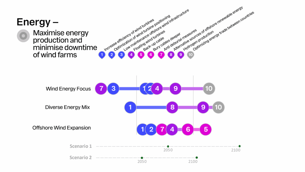
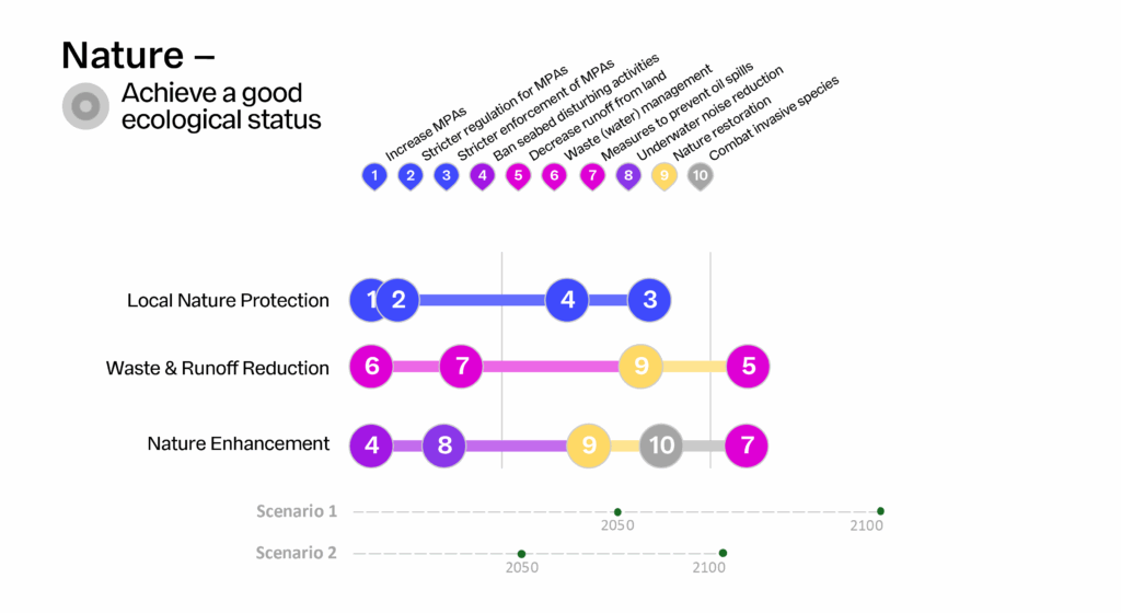
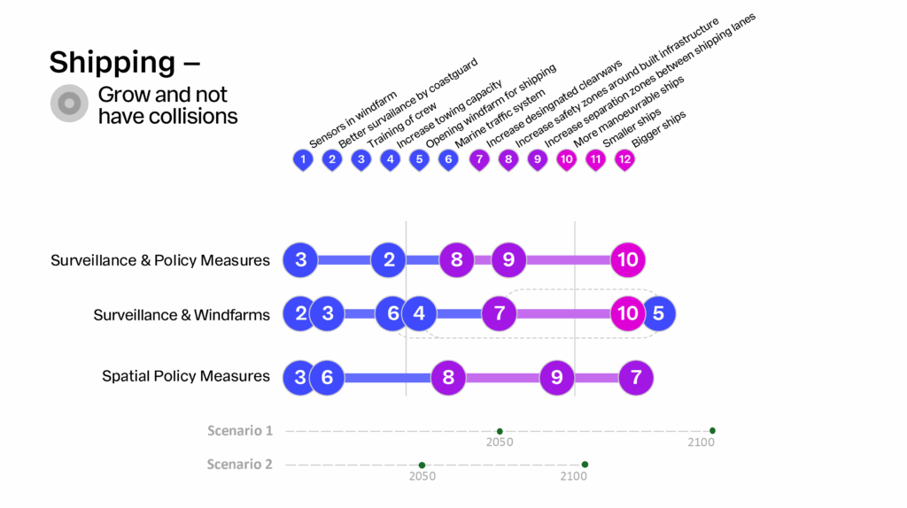
 The sectoral pathways for the North Sea are depicted in Tables 1, 2 and 3. For each sector, the objective is defined, and three distinct pathways have been developed, each based on a different underlying narrative. The pathways show which sequence of measures can be taken to ultimately achieve the sectoral objective. Each sectoral pathway was evaluated across four key criteria:

effectiveness, total cost, impact on maritime space and level of regret.


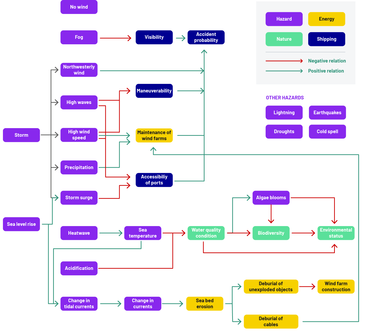
As previously described, there are interaction effects between different risk management measures and sectors, which can be either positive or negative. In some cases, these effects are not yet fully understood and contribute to overall uncertainty. Figure 3 presents an overview of all possible combinations of sectoral pathways, highlighting: 1) the associated interaction effects as the net result of positive and negative effects; and 2) the number of uncertainties for each sector.


Since the effects of uncertainties are unclear it is challenging to incorporate them into the assessment. However, sectoral  stakeholders can use these uncertainties as indicators and remain aware that additional insights may be needed before
implementing the corresponding pathways.


 Figure 3: Overview of sectoral pathway interactions and uncertainties.


At this stage, it remains unclear which specific sectoral pathway is preferred by stakeholders within each sector. As a result, the number of potentially preferred combinations is relatively large, making it more challenging to draw definitive conclusions. However, when focusing exclusively on the criterion of effectiveness in achieving each sector’s objectives, the following combinations of pathways are most likely to be chosen:

  • Nature Enhancement || Offshore Wind Expansion || Surveillance & Windfarms
  • Local Nature Protection || Offshore Wind Expansion || Surveillance & Windfarms
  • Nature Enhancement || Wind Energy Focus || Surveillance & Windfarms
  • Local Nature Protection || Wind Energy Focus || Surveillance & Windfarms

The above selection of preferred pathways focuses exclusively on the effectiveness of the pathways, without yet considering cost, impact on maritime space, or the potential for regret. In this context, the analysis shows that maximizing positive synergies from interaction effects and achieving the highest overall effectiveness in meeting sectoral objectives require cooperation among
stakeholders within and across sectors.


For a complete overview of the background, see D3.4 – Final Report on Forward-Looking DRM Pathways and Recommendations for Upscaling and Transferability (DOI 10.5281/zenodo.17245463).


References: 
  1. KNMI ’23. Climate scenarios for the Netherlands, KNMI, De Bilt, KNMI Publication 23-03a.