
- STEPS
- Finding a system definition
- Characterisation of direct risk
- Characterisation of indirect risk
- Evaluation of direct and indirect risk
- Defining risk management options
- Accounting for future system rate
Danube
SUMMARY
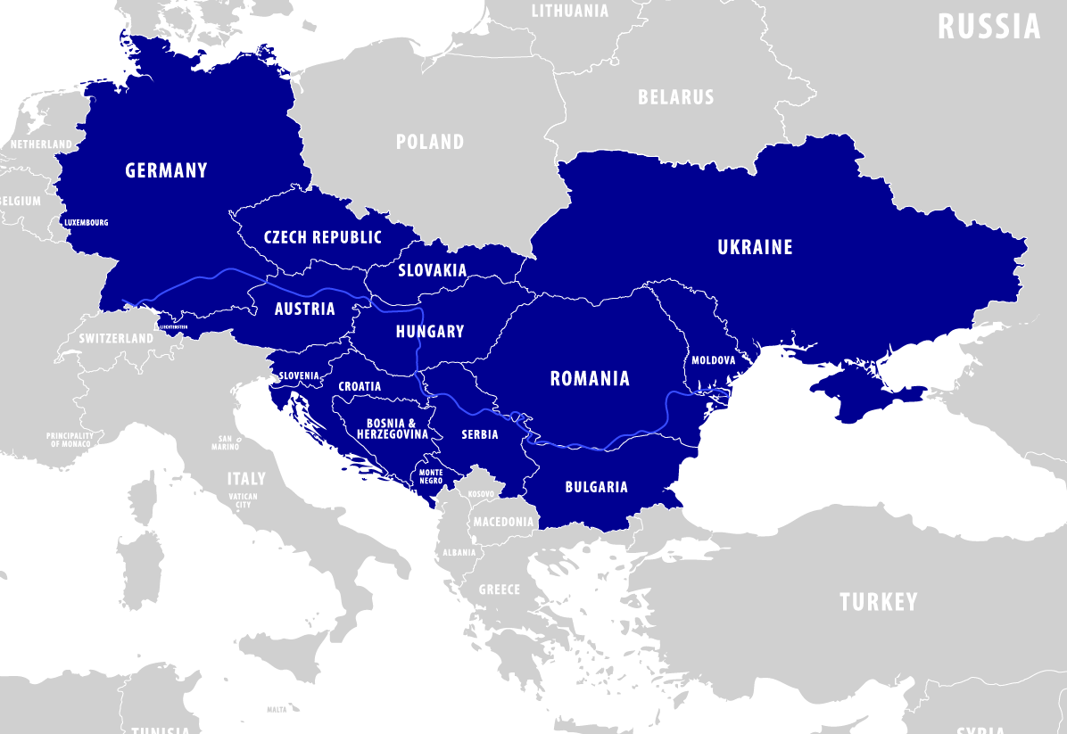
The Danube River Basin is a diverse and interconnected region spanning a total of 19 countries and home to over 80 million people who rely on the river for vital resources like water, energy, and agriculture. The region faces significant socio-economic disparities and is highly vulnerable to natural hazards, including floods, droughts, earthquakes, and landslides. Recent multi-hazard events, such as the 2002 and 2014 floods and the 2020 Croatia earthquakes, have caused billions in damages, highlighting the region’s need for resilience and coordinated disaster management.
The Danube Region Pilot focused on strengthening resilience to multi-hazards within the Danube Region, characterized by interconnected economies and cross-border challenges. Specifically, the pilot encompassed 14 countries that form part of the EU’s Danube Strategy Point, a key macro-regional initiative. To that aim, we sought to understand how multi-hazards propagate and their cascading effects on interconnected sectors.
A multi-disciplinary approach integrated qualitative and quantitative methodologies. Extensive stakeholder consultations highlighted challenges such as limited cross-border coordination, fragmented institutional frameworks, and insufficient climate adaptation efforts. Central to the analysis was also a macroeconomic Agent-Based Model (ABM), offering dynamic insights into cascading impacts. This was complemented by FIGARO data analysis for static sectoral links and CatSim methodology to calculate fiscal gaps for all Danube countries. Tools like the DAPP-MR framework supported adaptation pathways for agriculture and navigation while the concept of risk layering helped define strategies for the finance sector.
Initial work in the Pilot involved defining its system boundaries and statistically characterising hazard interrelationships. This formed the basis for the analysis of sectoral impacts, the construction of hazard scenarios, and the development of initial disaster risk management pathways. Later work focused on building multi-sectoral and multi-risk adaptation pathways that use forward-looking strategies and integrate past findings to create adaptive, resilient solutions.
This collaborative approach underscored the need for regional cooperation and innovation in managing complex, interconnected risks. By aligning efforts across sectors and borders, the Danube Region Pilot contributed to a safer, more sustainable future.
Relationship to the MYRIAD-EU Framework
Finding a system definition
The research conducted in the Danube Region used a “system of systems” approach to examine how the 14 countries in the Danube Region are interconnected. This approach helped us understand that each country is part of a larger system, allowing us to focus on regional issues rather than national and local disaster risk management. In other words, in the Danube Pilot, countries were the scale of analysis and we were interested in the interconnections between these countries.
The process of defining the system also involved identifying key stakeholders whose expertise and regional perspective are essential. In this context, we engaged with core organizations such as The EU Strategy for the Danube Region (EUSDR) – and within the EUSDR Prioarity Area 5 (PA5) -, the International Commission for the Protection of the Danube River (ICPDR), and the Global Water Partnership Central and Eastern Europe (GWP-CEE). These organizations provided unique insights into the regional dynamics and are crucial for understanding the interconnectedness of the countries involved in disaster risk management across the Danube Region.
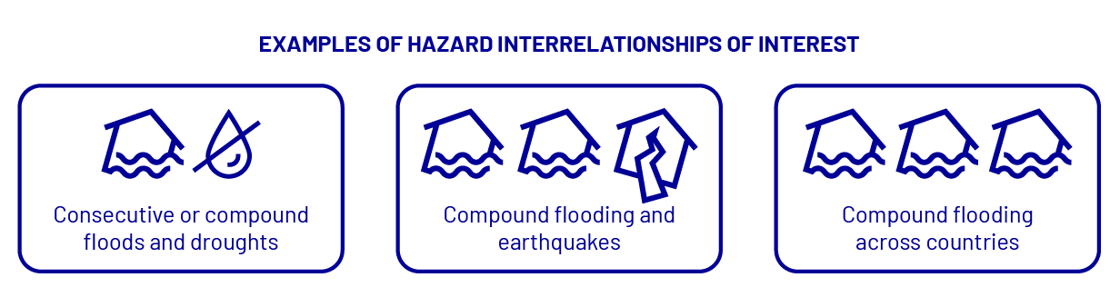
Given the large scale and many different hazards impacting the region, one of our main goals was to identify natural hazards that have a potential for regional impact. Through initial stakeholder workshops (Šakić Trogrlić et al., 2024), we found that flooding, earthquakes, and droughts are the top three concerns due to their potential impacts across multiple countries. We also looked at how these hazards could co-occur, follow after one another or trigger each other, which can create even more challenges and requires its own management. Identifying individual hazards and their combinations was essential for informing quantitative modeling in following steps, making it possible to assess risks more precisely and to develop targeted solutions.
Additionally, we focused on three important sectors: agriculture, finance, and transport. These sectors were chosen due to their relevance to the pilot project and their strong economic interconnections, particularly in the context of natural hazards. Following the process of Dynamic Adaptation Policy Pathways (DAPP), we analyzed these sectors with respect to the various drivers of future change they are facing and the causal relationships arising from them. We identified the sectors’ objectives for the future in the Danube Region and outlined tailored responses needed to enhance resilience and sustainability in the face of evolving climate change challenges and their cascading effects. An example of this analysis for the navigation sector is given in Table 1.

Characterisation of direct risk
Assessing the direct risks of multi-hazard events in the Danube Region followed a three-step process. See below a short description of each of these steps.
a. Literature review of damage data of past hazard events (droughts, floods, earthquakes) (EMDAT)
b. Collaboration with WP5 to expand on losses on sectoral basis
- a drought followed by a flood
- consecutive flooding
- compound flooding
- compound flooding and earthquakes
- a consecutive flooding and earthquake
The model spans 26 EU nations (excluding Malta) and covers 9 countries in the Danube Region, incorporating 237 NUTS-2 regions. It includes 64 industries, classified by the NACE system, including Agriculture, forestry and fishing, Transporting and storage and Financial and insurance activities, amongst others. Calibrated using data from FIGARO and Eurostat, with 2016 as the reference year, the model simulates economic dynamics every quarter for a three-year period. It models the behavior of all economic agents—households, businesses, banks, and governments—based on available national accounts data.
We used catastrophe modelling (the CatSim method) to study the impact of natural hazards on the financial sector in the Danube Region, focusing on governments as the main risk bearers. We used data for several natural hazards, including earthquakes, winds, storm surges, tsunamis, and floods. Additionally, we considered the impact of reduced government funds due to Covid-19 allocations, which increases the risk that natural hazards cannot be managed effectively. We used probabilistic data for these hazards, primarily from the Global Assessment Report on Disaster Risk Reduction (UNISDR 2015) and flood risk estimates, combining them into a single multi-hazard loss distribution (Hochrainer-Stigler et al., 2017). To avoid overestimating risk by assuming dependencies between hazards, we convoluted the loss distributions. We also assumed independence between events and no losses for events with a return period below 10 years, following a numerical approach (Hochrainer-Stigler et al., 2017).
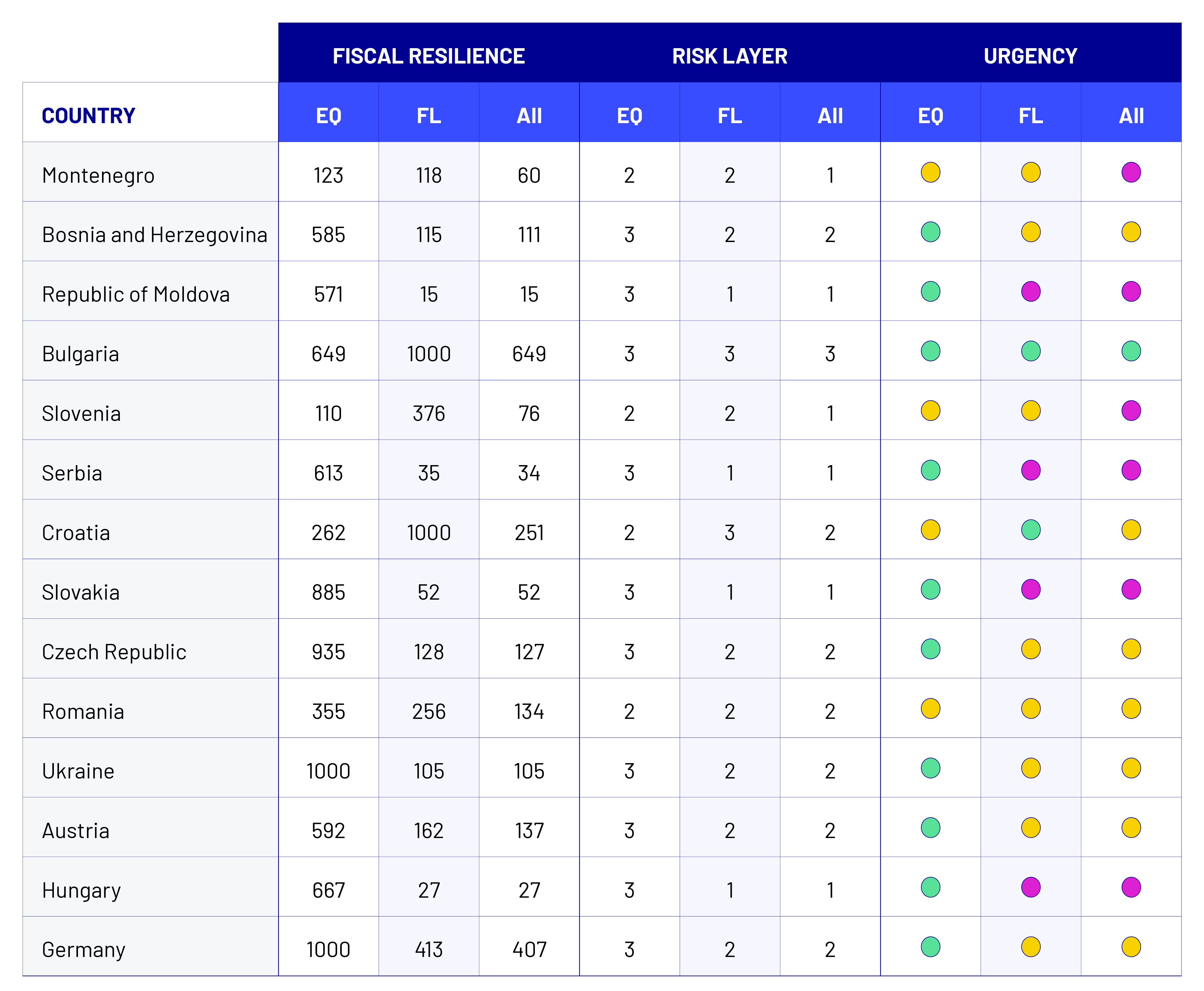
Using a risk-layer approach and catastrophe modeling, we assessed how fiscal stress changes over time and across different scenarios. Our findings showed that some countries have high fiscal resilience, with financial gaps appearing only in extreme events, while others face fiscal gaps more frequently, especially when considering multiple hazards. Our study showed that countries like Germany, Austria, and Bulgaria have high fiscal resilience, with financial gaps occurring only in extreme events, while countries like Serbia, Hungary, and Slovakia face fiscal gaps more frequently, even in less severe scenarios. We emphasized the importance of long-term risk management strategies at both the country and regional levels, as natural hazards can have cross-border effects. A detailed analysis is available in a recently published paper, with this deliverable providing a summary.
c. Identification of key risks through stakeholder workshops
We actively engaged stakeholders in the co-production process to gather input on the direct impacts of multi-hazard scenarios—particularly floods and droughts—on our three key sectors: agriculture, transport, and finance. Through Pilot workshops and focus group discussions, we worked closely with stakeholders to identify and map sector-specific vulnerabilities and understand how risks are interconnected. This collaboration also provided valuable insights into managing transboundary and transsectoral risks through co-development and the application of the DAPP-MR approach.
We have also worked closely with stakeholders during our Pilot workshops to identify and map the main impacts and risks for our three key sectors. This collaboration helped us understand how different risks are connected in these sectors.
Characterisation of indirect risk
Static analysis:
To understand how risks can spread through the system, we looked at data from the FIGARO database, which contains economic information between EU countries. We focused our analysis on the flows between the agricultural, construction, transportation, and financial industries of the EU countries within the Danube region. We used a chord diagram (Figure 3) to visualize the inter- and intra-sectoral as well as intra- and international trade flows. The thickness and direction of the arcs in the diagram revealed the magnitude and direction of economic dependencies, highlighting how vulnerabilities in one sector could cascade into others. This analysis helped us get a first insight into potentially important economic connections and significant flows between sectors in the region that could lead to indirect risks after a hazard event. Typically, the largest flows (in monetary terms) occur between industries of the same countries, with smaller fractions used for exports, in particular, to the countries outside of the Danube region. Particular exceptions are the air and water transport industries in all Danube countries (except for Austria), which are more export-oriented.
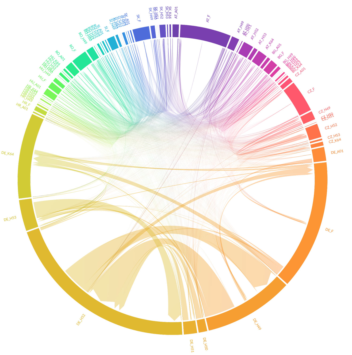
The chord diagram (Figure 3) highlights Germany as a dominant force in regional trade, with strong internal flows in sectors like land transport (H49), warehousing (H52), finance (K64), and construction (F). Germany also maintains significant trade links with neighboring countries such as Austria (AT) and the Czech Republic (CZ), often within the same sectors. Other countries show similar patterns but with smaller trade volumes. While most major flows are domestic, international connections within the same sectors remain significant. Notably, the trade flow between CZ_H49 and CZ_K64 points to potential sector vulnerabilities, stressing the need for ongoing dynamic analysis.
Dynamic analysis:
- a drought followed by a flood
- consecutive flooding
- compound flooding
- compound flooding and earthquakes
- a consecutive flooding and earthquake
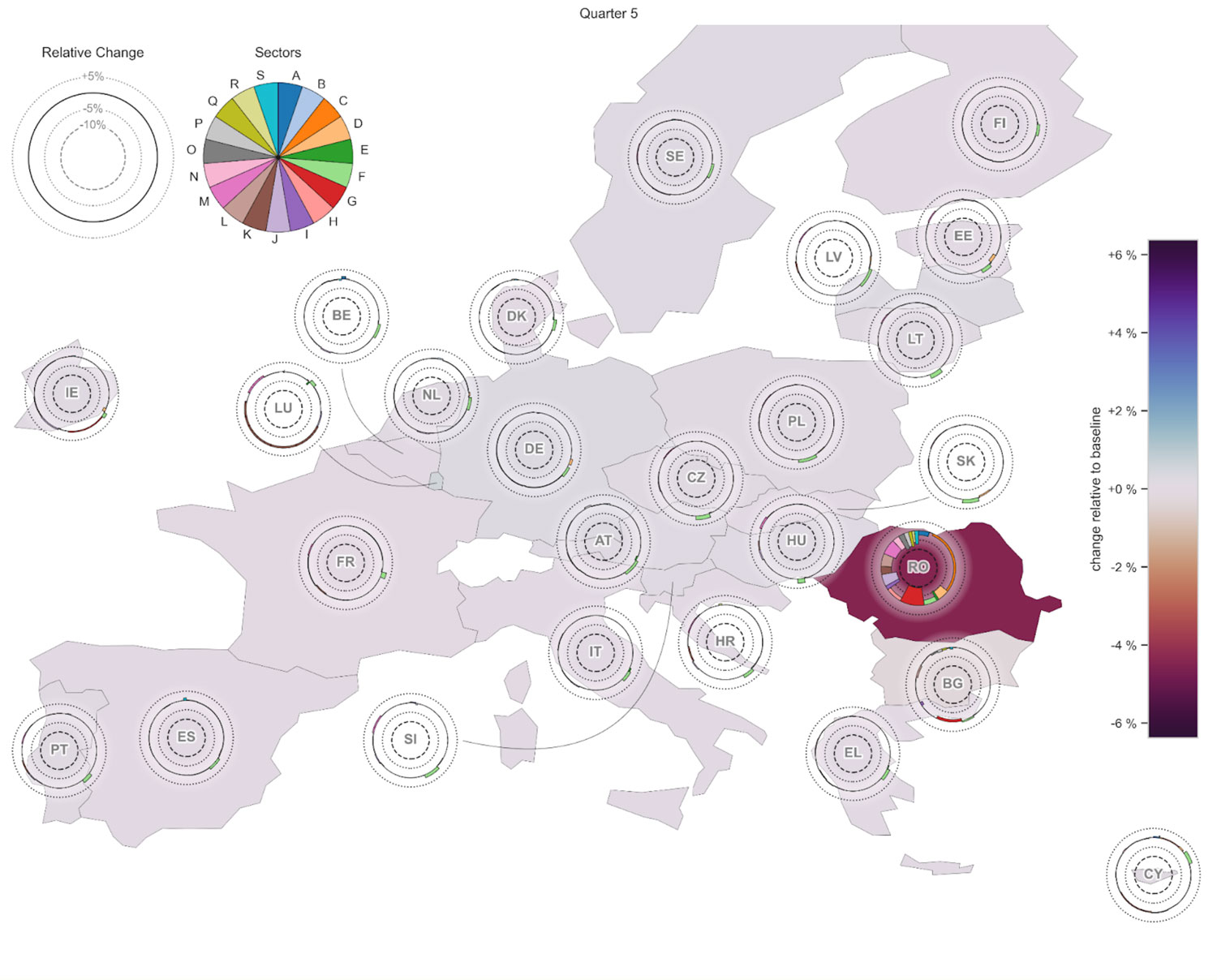
These scenarios were modelled after previous events, so, for example, an earthquake affecting Romania and Bulgaria in one simulation was similar to the 1940 Vrancea earthquake event, the strongest earthquake recorded in Romania in the 20th century (Figure 4). We also modeled a hypothetical scenario of all of these hazards happening consecutively. The modelling process allowed us to see how the direct effects of real hazards can affect different sectors and countries and manifest as indirect risks.
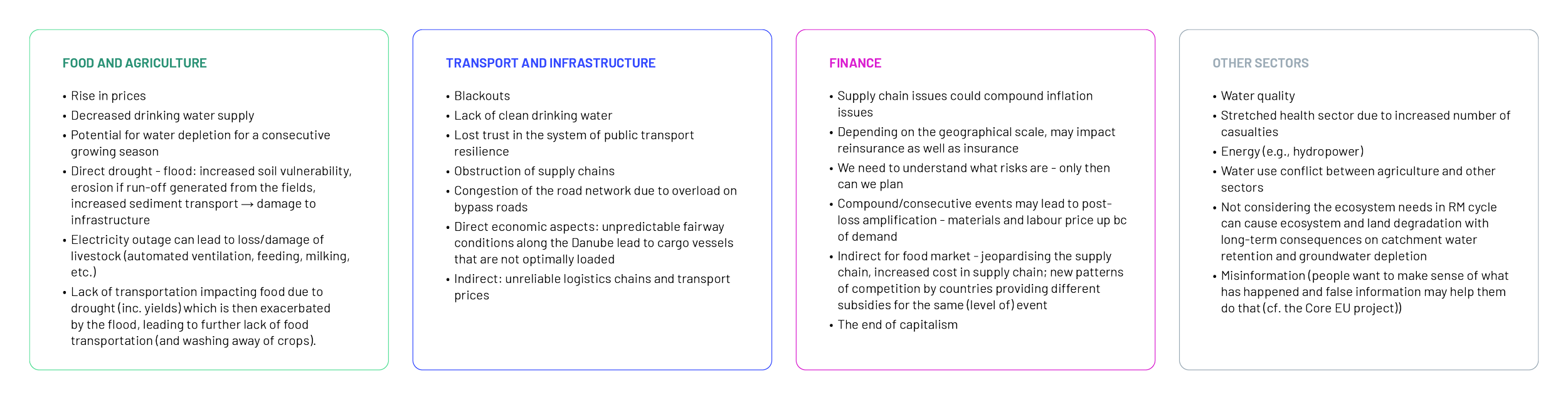
For the example of the earthquake event in Romania and Bulgaria (Figure 4), our analysis detects economic effects in the Danube Region and beyond. While the most notable declines in output, over a scale of sectors, can be seen in Romania and Bulgaria, which were directly hit by the hazard event. However, indirect effects can be observed in many sectors in other EU countries, where increased exports play a crucial role in supporting recovery efforts, highlighting economic adjustments in the aftermath of the event.
Our efforts have provided valuable insights into how interconnected economies in the Danube Region respond to various hazards. Therefore, our results show that a mix of national and cross-border strategies is essential for effective risk management and economic resilience in the Danube Region. Some concrete examples of our results include:
- Recovery Times Vary: Different countries recover from disasters at different speeds. For instance, in the Danube Region, countries like Germany and Austria show high fiscal resilience, with resource gaps occurring only at high return periods, while others like Serbia and Hungary face fiscal stress much sooner. This disparity highlights the importance of targeted support for less resilient countries, as well as the potential benefits of regional cooperation
- Sector Differences: The impacts of disasters vary significantly between sectors, such as agriculture and transport. Risk management strategies must be tailored to address specific needs. For example, fiscal gaps in the Danube Region emphasize prioritizing investments in sectors critical to reducing overall stress on national resources. This underscores the necessity of a sector-specific approach to strengthen fiscal and economic resilience.
- Multi-Hazard Impacts: When two disasters occur consecutively, like a flood followed by an earthquake, the compounded economic damage can be severe. Our study showed that fiscal gaps occur at earlier intervals in multi-hazard scenarios compared to single-hazard events in almost all countries in the region. This demonstrates the need for coordinated planning to address the interaction of various hazards and reduce the risk of cascading effects.
- Indirect Economic Losses: Economic impacts on one country often affect neighboring nations or the entire region due to interconnected economies. For example, an earthquake event in Romania can have reverberating effects across borders, affecting its neighboring countries. This interconnectedness highlights the critical need for shared risk strategies and regional cooperation to manage indirect risks effectively.
Evaluation of direct and indirect risk
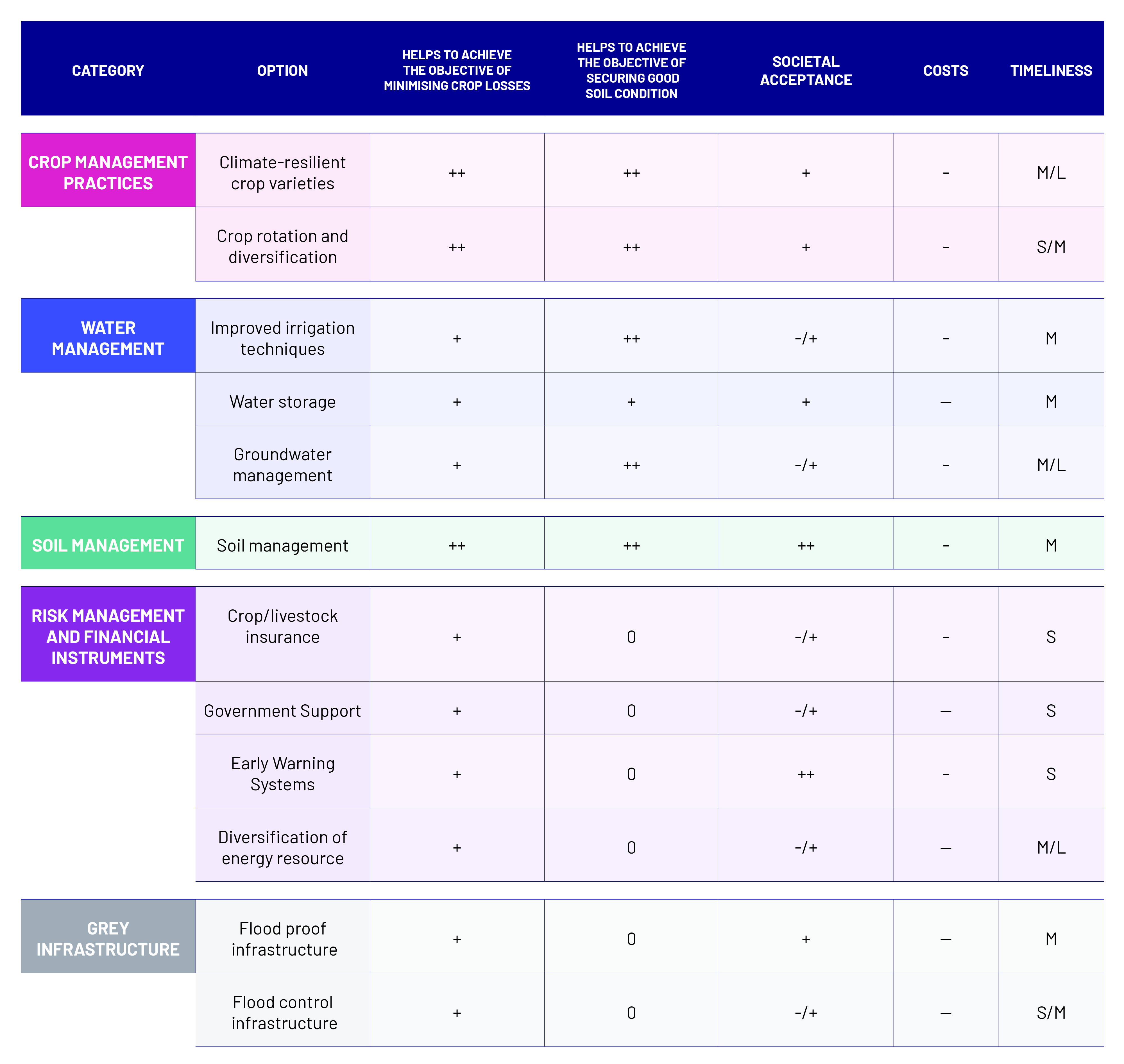
Our approach centered on developing structured pathways for our key sectors: agriculture, transportation, and finance. To do so, we worked closely with stakeholders during our first pilot workshop and two further focus group discussions to identify the main objectives, impacts and risks that concern the three key sectors in the region. This collaborative process allowed us to develop causal relationships for these sectors to better understand the system at hand and prioritize management options. For agriculture, for example, the primary objectives include preventing income losses for farmers and agricultural businesses, as well as fostering sustainable agricultural practices. To support these goals, we identified several key measures, such as enhancing soil health, ensuring water availability, and reducing nutrient pollution. All of this work was done within the framework of the Dynamic Adaptation Policy Pathways (DAPP).
As part of this process, risk evaluation was approached as a continuous dialogue with stakeholders, with a focus on their priorities and the co-production of knowledge. By incorporating their perspectives, we were able to align risk management strategies with sector-specific goals and values. This collaborative approach enabled us to define clear evaluation criteria for assessing the effectiveness and attractiveness of potential management options.
To pursue the sector-specific goals effectively, we conducted a comprehensive review of existing data on potential management options. We then engaged in discussions with stakeholders, including interviews and focus groups. to validate our findings, and to gain insight into the unique challenges of risk management within the sector. This process also enabled us to gather crucial input from stakeholders to establish evaluation criteria for how effective and attractive the proposed management options are.
Another key tool we used is the CatSim model, which helps identify gaps in financial resources (for a more detailed description of how we applied the method see step Characterisation of direct risk). By pinpointing these gaps, one can provide governments with essential indicators of when they may struggle to cover losses related to agricultural risks, help them identify which risks pose the greatest financial threats and guide where to prioritize investments in risk management. By understanding fiscal resilience and potential resource gaps, governments can make informed decisions about how to allocate resources for disaster preparedness, mitigation, and recovery. For example, in countries like Serbia and Slovakia, where fiscal gaps occur more frequently, investing in flood protection infrastructure or earthquake-resistant buildings could reduce the likelihood of facing financial stress during natural disasters. On a broader scale, these findings can also guide regional cooperation, as countries in the Danube Region are interconnected, meaning that a disaster in one country can affect neighboring countries. By planning together, these countries can build stronger, more resilient systems to manage both individual and shared risks.
Our work has laid a solid foundation for evaluating how well risk management portfolios align with sector objectives. We made significant progress in understanding the current state of risk management in our key sectors and how it can be improved to support local stakeholders and the wider community.
Defining risk management options
We conducted this work as part of developing Dynamic Adaptation Policy Pathways for Multi-Risks (DAPP-MR) for the agriculture and transport sector in the region. Initially, we gathered ideas for risk management in our key sectors through desk reviews and discussions with stakeholders in the first Focus Group meeting we conducted. Given the diverse conditions across the countries of the Danube Region, it has proven impractical to provide specific local solutions for tackling challenges related to floods and droughts for the entire region. Instead, our approach aligns with existing frameworks, like those from the International Commission for the Protection of the Danube River (ICPDR), which offers broad recommendations and allows countries to adapt them as needed. This way, we were able to identify management options that are of regional interest such as improving early warning systems or enhancing capacity building, while acknowledging the fact that each local community faces unique risks.
For the finance sector, we used a risk-layering method which helps in categorizing risk management options into three main areas: reducing risks related to low and medium losses, financing options like insurance for medium to extreme losses, and risk transfer mechanisms, such as external assistance for very severe losses. During our second Focus Group Discussion, we began exploring cross-regional instruments that could help mitigate the effects of risks shared across borders. This collaborative approach is vital for creating effective strategies that can be tailored to the specific needs of each country in the Danube Region.
Accounting for future system state
We incorporated future system states in our dynamic analysis of the economies of the Danube Region by using long-term climate change projections and resulting changing hazards patterns. Because of a projected increase in the frequency and severity of droughts due to climate change, it was our priority to incorporate drought scenarios into the model which allows for a more comprehensive assessment of climate-related risks in the region, particularly for sectors such as agriculture.
Additionally, we used the Dynamic Adaptive Policy Pathways for Multi-Risks (DAPP-MR) framework to understand how systems in our region may change in the future (Haasnoot et al. 2013). Through desk research and consultations with stakeholders, we gathered valuable insights as to how the conditions in the region might change in the future. It is important to stress again that the large size of the Danube Region made it difficult to make general statements about how the system will change in the future, since climate change will have varying effects on different areas in the region, especially when it comes to agriculture. Additionally, socio-economic factors and regional disparities further complicated the implementation of regional disaster risk management strategies, making it even more challenging to design a one-size-fits-all approach, particularly for a pilot of this scale.
Based on the aforementioned research, we developed sequences of adaptation responses per sector as strategies to address potential future challenges. Adaptation responses are designed to be flexible, allowing stakeholders to adjust them as one learns more about the risks and changes in the region. The sectoral pathways we developed then served as a basis for the multi-sectoral, multi-risk pathways we created together with our stakeholders. The multi-sectoral, multi-risk pathways highlight the need for cross-sectoral and cross-border collaboration and coordination in effectively and sustainably tackling risks stemming from natural hazards.
Our focus lay on identifying and addressing issues related to environmental changes and their impacts on local communities and economies. By engaging stakeholders, we ensured that our responses reflect the needs and concerns of those affected. We have developed effective pathways that can help the Danube Region to respond to various risks while enhancing resilience to future uncertainties.
- Identifying the key factors driving risk in future system states (e.g., due to processes such as climate change, economic change, land-use change, etc.)
- Defining/specifying the future system state according to the identified factors
Developing multi-risk pathways
In the Danube Pilot, the development of multi-risk Disaster Risk Management (DRM) pathways focused on capturing the transnational and systemic nature of risks affecting the region, where multiple hazards interact across borders and sectors with strong macroeconomic interdependencies. The pathways were developed using the Dynamic Adaptive Policy Pathways for Multi-Risk (DAPP-MR) approach, supported by system analysis and stakeholder engagement, to explore how floods, droughts and earthquakes may jointly impact key sectors over time, and how adaptive strategies can be sequenced under uncertain future condition.
Pathway development built on a structured understanding of sectoral systems and causal relationships, particularly for agriculture and navigation, while explicitly considering spill-over effects to the financial sector. Causal chain analyses were used to map how flood and drought events propagate through physical impacts, sectoral disruptions and economic consequences. Based on this system framing, plausible future scenarios for the Danube Region were defined and used to test the robustness of alternative DRM measures under changing hazard frequencies and intensities. Sector-specific measures were then identified and qualitatively evaluated in terms of effectiveness, feasibility, costs and social acceptance, forming the building blocks of the pathways.
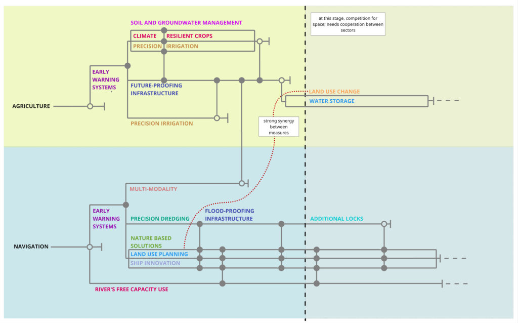
The resulting sectoral pathways illustrate adaptive sequences of measures for agriculture and navigation, highlighting adaptation tipping points (ATPs) where existing measures no longer suffice, and opportunity tipping points (OTPs) where proactive transitions to alternative measures become advantageous. Importantly, the Danube Pilot also developed cross-sectoral pathways, showing how increasing competition for water resources between agriculture and navigation may necessitate stronger coordination and cooperation between sectors. These cross-sectoral pathways make explicit when isolated sectoral action is no longer viable and collective governance responses become critical to avoid escalating multi-risk impacts.
Overall, the Danube multi-risk pathways provide a forward-looking, transnational perspective on DRM, emphasizing timing, sequencing and coordination of measures across sectors and countries. They support decision-makers in identifying when to maintain, adjust or transform current risk management strategies, and where cross-border and cross-sector cooperation is essential to manage cascading and systemic risks in the Danube Region.
References:
- Haasnoot, M., Kwakkel, J. H., Walker, W. E., & Maat, J. ter. (2013). Dynamic adaptive policy pathways: A method for crafting robust decisions for a deeply uncertain world. Global Environmental Change, 23(2), 485–498.
- Hochrainer-Stigler S., Mechler R., Laurien F. (2017). Fiscal resilience challenged. In The GAR Atlas: Unveiling Global Disaster Risk, United Nations International Strategy for Disaster Reduction (UNISDR), Geneva, Switzerland, 47–52.
- Šakić Trogrlić, R., Reiter, K., Ciurean, R.L., Gottardo, S., Torresan, S., Daloz, A., Ma, L., Padrón Fumero, N., Tatman, S., Hochrainer-Stigler, S., de Ruiter, M.C., Schlumberger, J., Harris, R., Garcia-Gonzalez, S., García-Vaquero, M., Arévalo, T., Hernandez-Martin, R., Mendoza-Jimenez, J., Ferrario, D., Geurts, D., Stuparu, D., Tiggeloven, T., Duncan, M., & Ward, P. (2024). Challenges in assessing and managing multi-hazard risks: A European stakeholders perspective. Environmental Science & Policy 157 e103774. 10.1016/j.envsci.2024.103774.
- UNISDR (2015). Global Assessment Report on Disaster Risk Reduction. Geneva, Switzerland