
- STEPS
- Finding a system definition
- Characterisation of direct risk
- Evaluation of direct and indirect risk
- Defining risk management options
- Accounting for future system rate
Canary islands
SUMMARY
Island regions worldwide face complex challenges related to sustainability and resilience, driven by the need for climate change adaptation and exacerbated by economic dependence on tourism. The Canary Islands Pilot provides a comprehensive framework for multi-hazard risk assessment, leveraging its diverse stakeholder landscape and distinct regional context, offering a unique testing ground for MYRIAD-EU methods and tools (Hochrainer-Stigler et al., 2023). The pilot identifies systemic vulnerabilities within the Water-Energy-Food Nexus —defined as the interdependencies in managing water, energy, and agri-food resources (Cabello et al., 2021)— and the tourism sector, emphasizing the need for cross-sector coordination and improved governance.
This approach enables the development of integrated, adaptive strategies and scalable resilience pathways that not only strengthen local risk management but also serve as a replicable model for other tourism-dependent island regions.
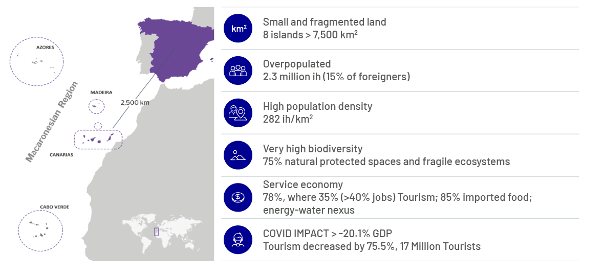
Since the kickoff meeting of the MYRIAD-EU Project coincided with the 2021 La Palma Volcanic Eruption, the event served as a real-time case study of multi-hazard interactions, including earthquakes, lava flows, toxic gases, and tephra fall. Indeed, the volcanic eruption exposed critical gaps in risk communication, particularly in tourism-dependent economies, where balancing safety messaging with economic concerns remains a challenge. It also highlighted deficiencies in institutional and sectoral preparedness, as well as limited public awareness and adaptive capacity. In addition, as the only volcanically active region in Spain, the Canary Islands faces additional bureaucratic complexities during post-disaster recovery, with volcanic eruptions compounding multi-hazard exposure. This complexity is further exacerbated by future climate-induced drought stress, which threatens water availability and complicates resilience and long-term adaptation efforts.
The pilot’s methods and outcomes, validated through an extensive participatory approach, identified critical interdependencies and potential risk dynamics across sectors. In addition, by examining the implementation of the Disaster Risk Management (DRM) strategy during the volcanic event, the pilot highlights the framework’s effectiveness in capturing the complexities of systemic multi-hazard risks.
These insights inform the development of adaptive, forward-looking strategies specifically tailored to enhance the resilience of the Canary Islands as a tourism destination. For instance, the need for tailored risk management frameworks, addressing unique island vulnerabilities, improving information sharing, fostering public awareness of systemic risks, and promoting adaptive policies to enhance resilience.
Relationship to the MYRIAD-EU Framework
Finding a system definition
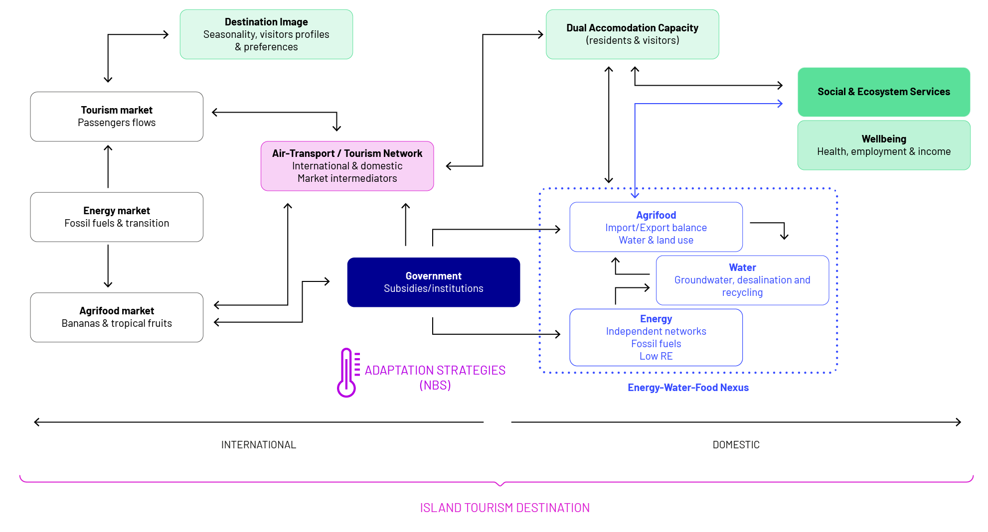
To define the system, the pilot employed a “system of systems” approach alongside the Collaborative System Analysis Approach (CSAA) to investigate sectoral and spatial interconnections within island tourism destinations. This framework emphasises the mutual dependencies and shared resource demands between activities that support both tourism and resident needs, highlighting the intricate linkages within the Water-Energy-Food (WEF) Nexus and risk governance. The WEF Nexus refers to the interconnected system of water, energy, and food resources, where changes or pressures in one domain can significantly impact the others, requiring integrated management approaches (Harwood, 2018; Cabello et al., 2021).Through this analysis, researchers identified major policy barriers that make it difficult to strengthen resilience. These barriers reinforce rigid sectoral structures and prevent the adoption of more flexible and integrated risk management strategies. As a result, the system remains highly vulnerable to climate, economic, and environmental challenges, particularly in the face of multi-hazard risks such as prolonged droughts, resource scarcity, and extreme weather events.
To achieve a comprehensive understanding of these interconnections, the pilot integrated a structured stakeholder engagement process. This involved identifying and involving key actors from various levels of governance (local, regional, and national), research institutions, private sector stakeholders (including tourism operators, energy providers, and water utilities), and civil society organisations. Through interviews, workshops, and focus groups, stakeholders shared their perspectives on major multi-hazard scenarios and validated interdependencies between tourism and critical sectors, enhancing the understanding of shared vulnerabilities and adaptive capacities.
To deepen this analysis, the pilot developed and analysed three multi-hazard scenarios based on case studies of past disaster events, capturing the singular interactions among hazards in island regions. The analysis of these scenarios identified recurring patterns, referred to as impact chains, which demonstrate how systemic risks unfold and intensify across sectoral boundaries. In addition, these scenarios provided common dynamic vulnerability factors (social, economic, infrastructure, and institutional vulnerabilities) that affect the resilience of tourism destinations.
- Compound hazards: Tropical-like cyclones
Increasing in frequency and intensity, these storms trigger landslides and flooding, causing significant disruptions to coastal infrastructure, immediate tourism operations, and water and energy service security. - Triggering hazards: Drought-Heatwave-Forest fires, aggravated by Saharan dust episodes
This long-lasting scenario highlights compounding hazards that strain water resources, crop production, and stress island vulnerable energy systems. Saharan dust episodes further exacerbate health risks, reduce air quality, and intensify the effects of droughts and heatwaves. - Cascading hazards: Seismic swarms and volcanic eruptions: Exemplified by the 2021 La Palma eruption, these low-frequency, high-damage events immediately disrupted air traffic and tourism supply chains, harmed local ecosystems, and created long run cascading impacts across sectors. One major impact was the reduction in available tourist accommodation, which in turn led to decreased demand for air travel, affecting connectivity to the island. The volcanic eruption’s long-term impacts on the tourism industry goes beyond direct lava or ash-related damage, including flight cancellations due to a decline in visitor numbers driven by negative perceptions.
To enhance this analysis, the pilot incorporated in-depth stakeholder interviews, capturing insights into perceptions of dynamic vulnerabilities, governance challenges, and adaptive capacities. The analysis revealed that many stakeholder perceptions were largely hazard-specific and self-sector oriented, with limited recognition of interconnections between sectors, multi-risks, cascading impacts, and dynamic vulnerabilities. This lack of a holistic perspective highlights the potential influence of misperceptions on risk decisions, which can hinder the development and implementation of effective and forward looking DRM policies.
Additionally, a comprehensive desk review and literature analysis synthesised existing knowledge on hazard interactions, governance frameworks, and comparative insights from other island regions, enriching the findings and grounding them in broader systemic risk contexts.
Characterisation of direct risk
For the characterisation of direct and indirect risks, the study has employed a combination of scenario-based methodologies, historical data, and literature reviews to identify and quantify hazard-related vulnerabilities, particularly regarding risk susceptibility due to islands’ orography (Martín-Raya et al., 2023; Martín-Raya et al., 2024a and 2024b) and exposure (Ferrer & Herrera, 2024). To further characterise risk dynamics, two approaches were developed:
- A Storyline Approach was designed to frame the La Palma volcanic eruption within a multi-hazard and multi-risk context, using a 3 timeline framework (hazards, risks and risk management), to unravel how risk management decisions may have contributed to intensifying direct and indirect impacts within the scenario. For this purpose, the storyline narrative covers all phases of the Disaster Risk Management (DRM) cycle, including risk prevention and mitigation, the assessment of the system’s evolving vulnerability before the event, emergency response, and recovery planning. This provides a clear framework to evaluate risk dynamics during the multi-hazard volcanic event.
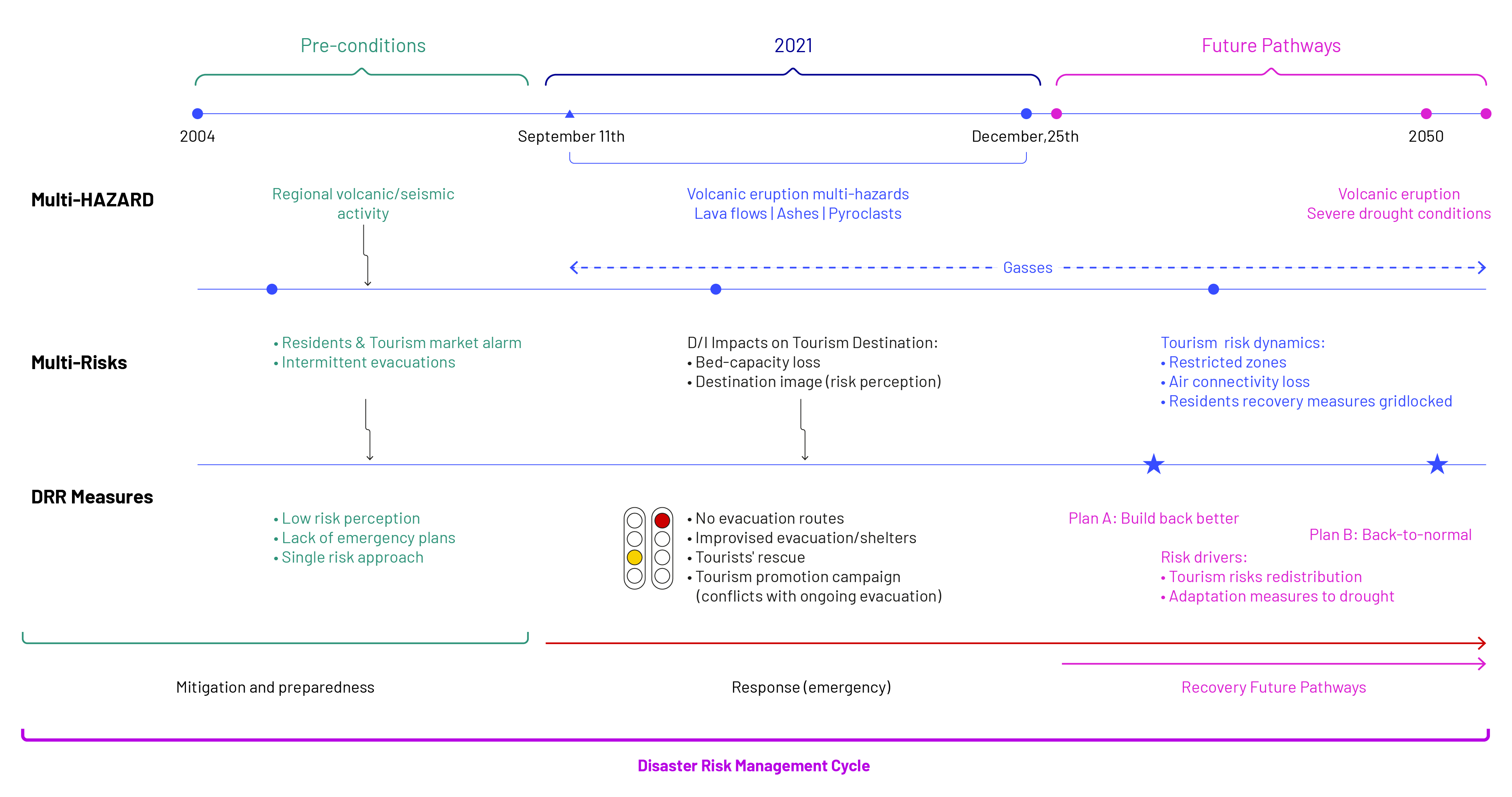
Central to this approach, disaster timelines and a double-entry matrix provided a comprehensive framework for characterising and understanding the dynamics of direct and indirect risks. The disaster timelines were designed to integrate the complexity of hazard interdependencies and the evolving risk dynamics. These timelines focused on four key dimensions:
- Timeline 1. Multi-hazard interdependencies: Exploring how different hazards interact and amplify risks.
- Timeline 2. Intersectoral dynamics of direct and indirect risks: Mapping how disruptions in one sector cascade into others creating systemic risks.
- Timeline 3. Decision-making within the DRM cycle: Analysing prevention, mitigation, emergency response, and recovery phases and their influence on risk dynamics.
The double-entry matrix was designed to systematically capture and characterise both direct and indirect impacts of the eruption across multiple sectors, while also considering spatial and temporal dimensions. By integrating qualitative and quantitative data, the matrix provides a comprehensive analysis of how disruptions in services such as mobility, water, and energy, cascade into agriculture and tourism, generating systemic risks for residents and ecosystem services. Additionally, the matrix has been instrumental in identifying how cascading volcanic hazards amplify risk dynamics spatially and over time, ultimately intensifying the overall impact of the disaster.
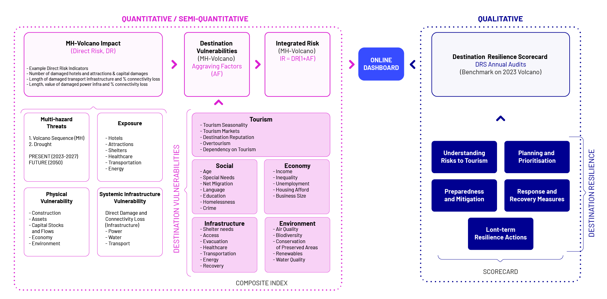
2. Building on this analysis, the pilot team, together with Risklayer has extended its focus to future risks by designing a multi- hazard scenario that simulates a volcanic eruption followed by a severe drought in the region. This scenario, set in 2050, explores the potential impacts on La Palma’s tourism sector and broader socio-economic systems. For this purpose, we are producing a software package, specifically -designed for the Canary Islands pilot. This tool is built to capture both direct and indirect risks associated with complex multi-hazard scenarios. It performs a comprehensive 30-year analysis for the Canary Islands, combining fuzzy logic with quantitative data. By incorporating diverse hazard scenarios, such as volcanic eruptions and droughts, the software provides a holistic view of exposure-at-risk. Building on this tool, we are also developing a quantitative model to calculate a Risk Integrated Index specifically for volcanic eruptions in La Palma’s districts. This index quantifies risk levels by integrating various metrics providing a detailed analysis of localised vulnerabilities to support better risk management and decision-making.
This holistic perspective maps the complex interconnections and systemic vulnerabilities within the multi-hazard scenario.
Evaluation of direct and indirect risk
The objective of evaluating direct and indirect risks is to determine which risks require action and should be managed or minimised for the future. This evaluation is based on a comparison of the outcomes from both direct and indirect risk characterisation against an established risk evaluation criteria. For this purpose, the pilot team, together with Risklayer, is developing a Destination Resilience Scorecard (DRS), a qualitative instrument designed to assess the governance aspects of disaster risk management and resilience in tourism destinations. The tool will leverage the storyline disaster analysis and existing volcanic risk planning in the region, within a participatory validation process.
The DRS is designed to evaluate and enhance the resilience of tourism destinations by assessing critical success factors that influence risk management effectiveness. It focuses on four key dimensions:
- Risk Awareness – The ability of tourism stakeholders to recognise and understand multi-hazard risks.
- Crisis Preparedness – The effectiveness of emergency response planning and risk mitigation strategies.
- Economic Stability – The capacity of tourism economies to withstand and recover from crises.
- Institutional Coordination – The integration of governance mechanisms and stakeholder collaboration in risk management.
Each dimension is measured through different performance criteria supported by qualitative and quantitative indicators, ensuring a comprehensive evaluation of vulnerabilities and strengths. The assessment process incorporates stakeholder surveys, expert consultations, and policy reviews, facilitating an evidence-based approach to resilience building. By comparing destinations against standardised criteria, the DRS will serve as a benchmarking tool, enabling policymakers and tourism managers to identify priority areas for action and develop targeted interventions for risk reduction.
A key advantage of the DRS is its scalability. Initially developed for the Canary Islands Pilot, its adaptable framework allows for implementation in other tourism-dependent regions facing multi-hazard (dynamic) risks. This flexibility supports cross-destination learning, fostering the exchange of best practices and comparative resilience assessments.
As part of its integration into the MYRIAD-EU Framework, the DRS will undergo validation through a Focus Group, where stakeholders will refine its indicators and scoring system based on the volcanic risk activation plan in the Canary Islands. Moreover, stakeholder participation will contribute to developing risk management strategies tailored to reduce tourism destinations’ vulnerability, ensuring that resilience planning is both context-specific and actionable.
Defining risk management options
At the governance level, the DRS will play a pivotal role in shaping strategies within the recently developed Volcanic Risk Management Plan, which is set to serve as a model for all islands. This plan is designed to strengthen preparedness, response, and recovery across the three stages of the DRM cycle, while, for the first time, explicitly integrating tourism vulnerability into regional risk planning. By recognising tourism as an essential part of risk governance, the plan identifies ways to strengthen disaster resilience, addressing sector-specific challenges and promoting a more comprehensive, adaptable, and multi-sectoral approach to managing tourism-related risks.
At the sectoral level, a detailed analysis has been conducted to evaluate how different economic sectors in La Palma are vulnerable to future climate-driven risks, particularly volcanic hazards and climate-induced water stress. This assessment has examined existing adaptation strategies in the region, focusing on their effectiveness in mitigating long-term risks. The insights gained from this process will help develop multi-risk pathways that integrate economic recovery, resource efficiency, and systemic interdependencies. By addressing these interconnections, the analysis ensures that short-term risk reduction measures are identified.
Accounting for future system state
The RiskLayer software, aforementioned in section 4, is incorporating post-eruption recovery actions across tourism, agriculture, water, and energy sectors to provide a comprehensive vulnerability assessment of the Canary Islands’ system by 2050. This modelling approach ensures that future multi-hazard risk scenarios accurately reflect the long-term effects of reconstruction, changes in exposure, policy adjustments, and adaptive measures.
By integrating sector-specific recovery dynamics, the software will project how the region’s resilience, infrastructure capacity, and resource availability evolve over time. A key focus is assessing the vulnerability of the system to a future volcanic eruption in 2050 alongside water scarcity, considering how past recovery strategies either strengthened or exacerbated sectoral interdependencies.
This approach provides decision-makers with a forward-looking risk evaluation, identifying potential weaknesses in recovery planning and ensuring that adaptive strategies are aligned with long-term sustainability and resilience objectives for La Palma and other multi-hazard-prone island regions.
Developing multi-risk pathways
The Canary Islands pilot is developing Dynamic Adaptive Policy Pathways for Multi-Risks (DAPP-MR) to enhance resilience in La Palma’s tourism and agriculture sectors. The goal is to improve the understanding of short-term sectoral interactions, resource dependencies, and climate-driven vulnerabilities, ensuring that risk mitigation strategies remain robust and flexible to evolving climate conditions. So far, the pilot has achieved the first measurable development pathways for tourism and agriculture, considering both pessimistic and optimistic climate scenarios.
- Sector-Specific Adaptation Pathways under Climate -optimistic and pessimistic- scenarios for Tourism and Agriculture
The tourism sector pathways address two key challenges: rebuilding bed capacity after the volcanic eruption and managing water consumption under increasing climate stress. Three pathways were explored:
- An intensive, proactive model emphasising rapid expansion and infrastructure development.
- An extensive, adaptive model prioritising gradual, sustainable growth and water conservation.
- A baseline scenario maintaining existing regulatory conditions and industry trends.
Each scenario considers limits on air travel, evolving tourist demand, and the impact of interventions such as sustainable hotel expansion, community-led regenerative accommodations, and water-saving technologies.
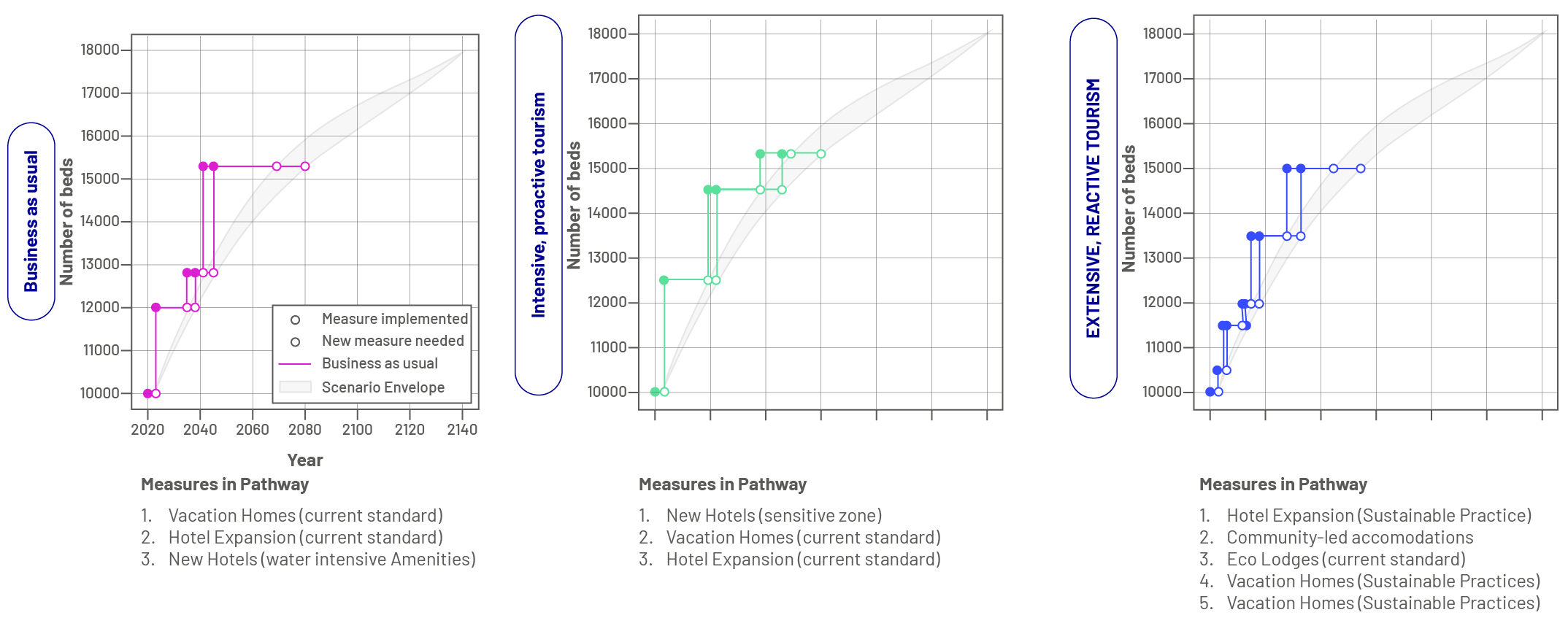
In the agrifood (export crops) sector, the pathways focus on optimising water use efficiency while ensuring economic viability. Given La Palma’s reliance on water-intensive export crops like bananas, the study compares business-as-usual agricultural practices with fundamental transformations, including precision irrigation, water-efficient crop selection, and alternative water sources.
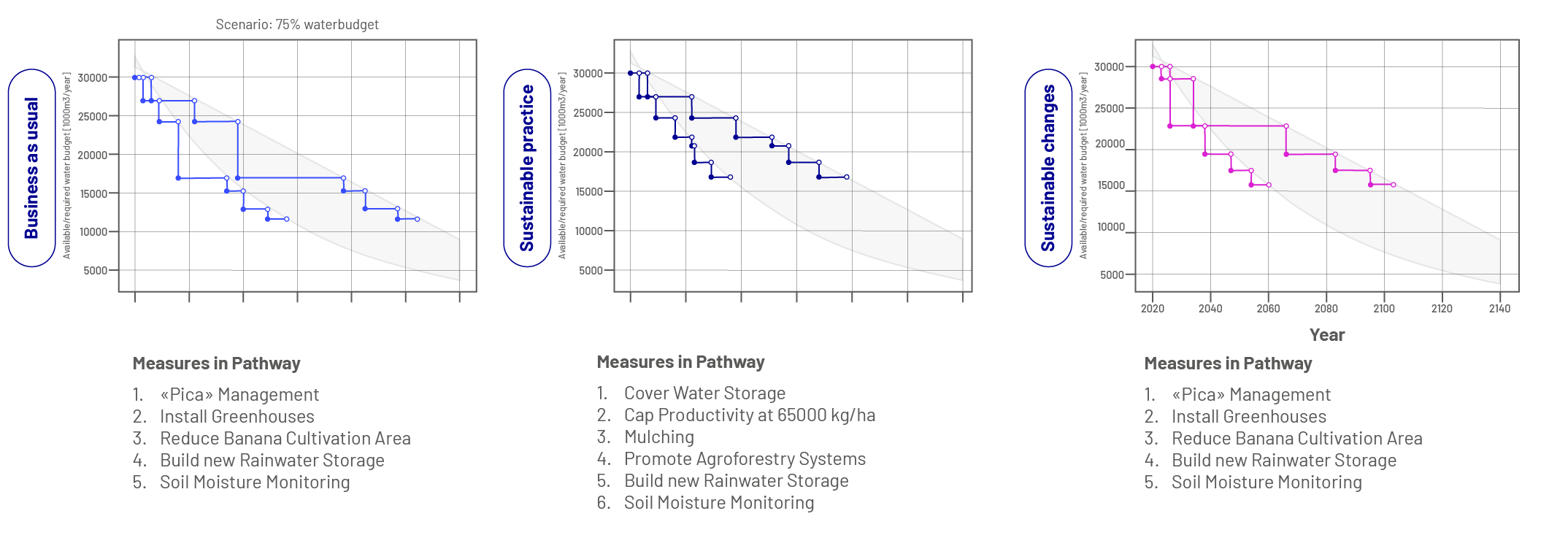
According to our findings, there is an urgent need for integrated water governance to balance competing demands across sectors.
2. Cross-sectoral pathways: interactions between tourism and agriculture
A critical aspect of this analysis is the recognition that decisions in one sector directly affect the resilience of another. For instance, different tourism development strategies influence water demand, which in turn affects the feasibility of water-saving measures in agriculture. Likewise, land use competition between tourism infrastructure and agrifood production necessitates coordinated governance frameworks to ensure equitable and sustainable resource distribution.
Integrated Multi-Risk Governance and Policy Strategies
The pilot integrates sector-specific pathways into a comprehensive multi-risk strategy, evaluating trade-offs, synergies, and governance mechanisms to ensure effective risk management. The cross-sectoral approach focuses on:
- Balancing economic recovery with sustainable resource use, ensuring both tourism and agriculture can coexist without exacerbating vulnerabilities.
- Strengthening governance coordination, fostering collaborative decision-making across public and private sectors.
- Developing flexible adaptation strategies, allowing both sectors to respond dynamically to emerging hazards and economic shifts.
Knowledge co-creation in the Canary Islands Pilot
To ensure practical applicability, the pilot employs participatory processes, modeling tools, and scenario-based stress testing. Stakeholders play a key role in refining multi-risk pathways, validating synergies and vulnerabilities, and shaping long-term risk governance strategies. In this context, the implementation of the MYRIAD-EU Framework points to the need for a systemic and forward-looking approach to risk management in tourism-dependent island economies. Through extensive stakeholder engagement, the pilot has demonstrated that overcoming sectoral silos, encouraging participatory decision-making, and promoting integrated governance are crucial for strengthening resilience.
A key outcome of the pilot has been the recognition that long-term risk planning and proactive adaptation strategies must be embedded in policy and institutional frameworks, with an urgent need for regulatory reforms. Moreover, the pilot has identified public awareness campaigns as a crucial tool for improving risk perception among both residents and visitors. By integrating these insights into scenario-based policy pathways, the Canary Islands Pilot provides a scalable model for implementing multi-risk strategies in island regions. This ensures that resilience planning remains holistic, adaptive, and aligned with future climate and disaster risks, serving as a blueprint for other tourism-dependent island economies facing similar challenges.
References
- Cabello, V., Romero, D., Musicki, A. et al. Co-creating narratives for WEF nexus governance: a Quantitative Story-Telling case study in the Canary Islands. Sustain Sci 16, 1363–1374 (2021). https://doi.org/10.1007/s11625-021-00933-y
- Ferrer, N., & Herrera, G. (2024). High-resolution modelling of island exposure to natural hazards tested with real disasters. Applied Geography, 165, 103239.
- Gordon, J. E. (2023). Climate Change and Geotourism: Impacts, Challenges, and Opportunities. Tourism and Hospitality, 4(4), 514-538.
- Harwood, S. A. (2018). In search of a (WEF) nexus approach. Environmental Science & Policy, 83, 79-85.
- Hochrainer-Stigler, S., Trogrlić, R. Š., Reiter, K., Ward, P. J., de Ruiter, M. C., Duncan, M. J., Silvia Torresan, Ciurean, R., Mysiak, J., Stuparu, D., & Gottardo, S. (2023). Toward a framework for systemic multi-hazard and multi-risk assessment and management. IScience, 26(5).
- ISTAC, Gobierno de Canarias (2024). Estadística de movimientos turísticos en fronteras de Canarias (Frontur). https://www.gobiernodecanarias.org/istac/.content/noticias/estadistica-movimientos-turisticos-fronteras-canarias-frontur-noticia-2024-noviembre.html
- Martín-Raya, N., Díaz-Pacheco, J., López-Díez, A., Dorta Antequera, P., & Cabrera, A. (2023). A lava flow simulation experience oriented to disaster risk reduction, early warning systems and response during the 2021 volcanic eruption in Cumbre Vieja, La Palma. Natural Hazards, 117(3), 3331-3351.
- Martín-Raya, N., Díaz-Pacheco, J., & López-Díez, A. (2024a). Multi-hazard risk assessment analysis in La Palma: an approach for risk mitigation. Geoenvironmental Disasters, 11(1), 33.
- Martín-Raya, N., Díaz-Pacheco, J., Antequera, P. D., & López-Díez, A. (2024b). Identifying urban prone areas to flash floods: The case of Santa Cruz de Tenerife. Progress in Disaster Science, 24, 100372.
- Singh, S. J., Huang, T., Nagabhatla, N., Schweizer, P. J., Eckelman, M., Verschuur, J., & Soman, R. (2022). Socio-metabolic risk and tipping points on islands. Environmental Research Letters, 17(6), 065009.