
- STEPS
- Finding a system definition
- Characterisation of direct risk
- Characterisation of indirect risk
- Evaluation of direct and indirect risk
- Defining risk management options
- Accounting for future system rate
VENETO
SUMMARY
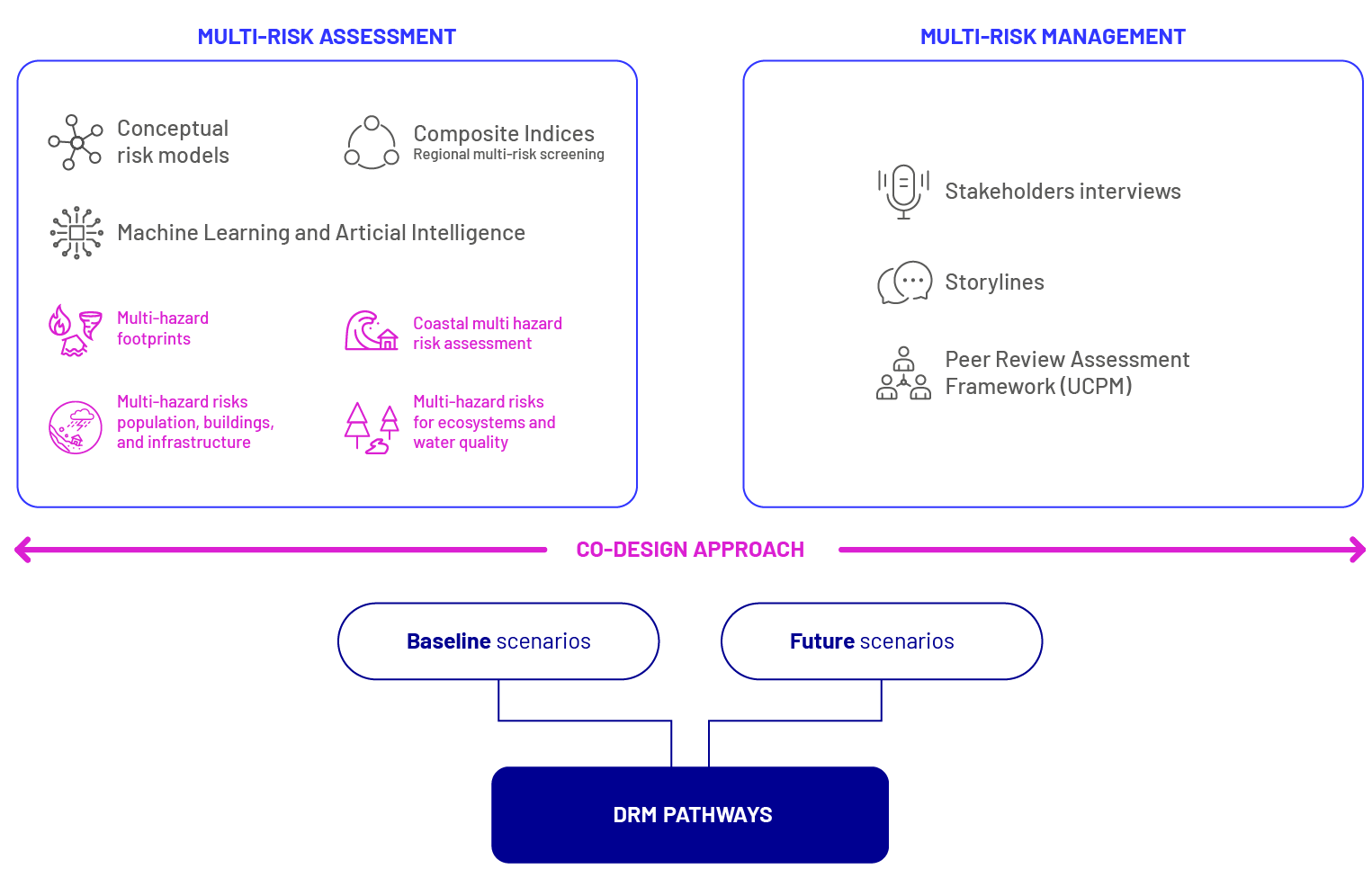
The research in the Veneto Region Pilot addresses the complex interactions between natural and human-induced hazards, worsened by climate change, which affect various socio-economic and environmental systems. Veneto’s diverse landscapes (ranging from mountains and plains to coastal areas) experience interlinked hazards such as heavy precipitation, strong wind, storm surge, river and coastal flooding, pluvial flood, drought, landslide, tornado, wildfire, and water pollution. The primary challenge was to create a forward-looking, multi-risk planning approach that effectively addresses these diverse landscapes. Focusing on sectors such as ecosystem and forestry, tourism, infrastructure and transport, and finance, with specific attention to water resources, the Veneto Region Pilot combines quantitative (e.g., Climate Risk Indicators, Machine Learning, and Artificial Intelligence) and qualitative (e.g., conceptual risk models, storylines, and participatory processes) methods to assess multi-hazard-risks (Figure 1). These tools were used to explore trade-offs and synergies among hazards and to assess risks in this highly varied region under the guidance of the MYRIAD-EU multi-risk systemic framework. The Union Civil Protection Mechanism Peer Review Assessment Framework (PRAF) was employed to co-develop forward-looking disaster risk management pathways accounting for future system states evidenced by Machine Learning algorithms (Mysiak et al., 2021).
Relationship to the MYRIAD-EU Framework
Finding a system definition
The system was defined through desk reviews and workshops with local stakeholders. This resulted in a multi-risk conceptual model identifying the main hazards affecting the Veneto Region, their interactions across different landscapes, the vulnerability categories and the main assessment endpoints. Hazards were classified following UNDRR standards, categorized by their drivers (e.g., temperature, precipitation, wind, flooding, terrestrial, environmental, biological) and by their onset speed (slow/sudden). Interactions were based on MYRIAD-EU categories, encompassing compound, consecutive, triggering, and amplifying hazards. The model addressed hot and dry events, such as heatwaves, droughts, and wildfires on land, and marine heatwaves and saltwater intrusion at sea, which can lead to secondary environmental and biological hazards such as air pollution, insect outbreaks, algal blooms, and eutrophication. Cold and wet events were also captured, including cyclones, storms, extreme winds, floods, and landslide-prone conditions in mountain areas, as well as coastal floods and slow-onset threats such as erosion and sea-level rise. Alternating interactions between droughts and extreme precipitation were also considered in the model. Exposure and vulnerability parameters include topography (e.g., elevation, slope, aspect, curvature), soil/geology (e.g., type of rocks, soil texture, skeleton, permeability), environmental (distance to rivers, distance to urban areas, land use, vegetation types), socio-economic (e.g., population, buildings, sectoral GVA). Sectoral impacts include health (excess mortality), tourism (number of arrivals), ecosystems (river water quality), and finance (e.g., exposed buildings).
This multi-risk conceptual model informed multi-hazard scenarios for Machine Learning applications. These included climate hazard interactions, territorial vulnerability, coastal impact assessments, and sector-specific risk analyses for ecosystems, populations, buildings, and infrastructures.
Characterisation of direct risk
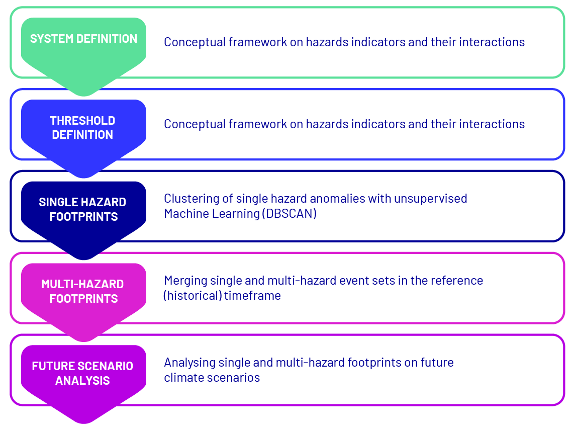
Direct risk assessment in the Veneto Region Pilot combined qualitative methods (e.g., interviews and focus groups with local stakeholders) with quantitative, Machine Learning (ML)-based approaches (Ferrario et al., 2025a). An adapted version of the MYRIAD-HESA was implemented to define multi-hazard footprints at the local level over the historical period from 1992 to 2021, using an unsupervised ML method called DBSCAN (Ester et al., 1996). This ML approach was used to create multi-hazard spatio-temporal footprints for current and future scenarios, focusing on four climate hazards: extreme precipitation, high winds, heat anomalies, and droughts (Figure 2). Preliminary spatial analysis showed that, historically, heat and drought events were mostly frequent in the plains, while precipitation combined with wind and heat were more common in coastal and mountainous areas (Ferrario et al., 2025b).
Additional ML applications included supervised ML for assessing ecosystem and river water quality risks and territorial vulnerabilities (population, buildings, infrastructure) (Ferrario et al., in preparation). Preliminary findings were shared with core and sectoral stakeholders in focus groups, fostering collaboration on risk assessment strategies for the Veneto Region Pilot. Specifically, the application on water quality risks focused on understanding the interaction between extreme events (i.e., extreme precipitation, extreme heat, drought) and anthropogenic land use (i.e., agriculture and artificial surfaces) and their impacts on water quality (physical-chemical properties, specific pollutants, biological alterations). The study extended to all river water bodies of ecological interest in the Veneto Region (Nguyen et al., 2025). Additionally, ML-based susceptibility mapping was used to study landslides and wildfires and assess direct multi-hazard risks over several socio-economic assets (tourism, buildings, population, infrastructures).
Characterisation of indirect risk
Interviews with local stakeholders provided valuable insights into the multi-hazard and multi-risk landscape of the Veneto Region, clarifying key challenges and validating sector priorities initially identified for the project. Core stakeholder feedback confirmed the primary sectors for analysis and highlighted recent significant multi-risk events, particularly emphasizing the Vaia storm’s widespread impacts. Stakeholders recognized the Vaia storm (2018) as a pivotal event with extensive cross-sectoral effects across short-, medium-, and long-term timelines, marking it as an ideal benchmark event for co-creating a regional risk storyline. In focus groups, the discussion expanded to examine the direct and indirect impacts of the Vaia storm across sectors, as well as the primary challenges faced before, during, and after the event. Together with stakeholders, “what if” considerations were discussed to envision how current/future climate, environmental, and socio-economic conditions could intensify or alter Vaia-like events.
Evaluation of direct and indirect risk
Specific thresholds related to acceptable/tolerable risk levels were not identified and an in-depth evaluation of risks were not performed in the Veneto Region Pilot. Instead, the approach focuses on gathering qualitative insights from stakeholders. These opinions were collected through interviews and focus groups to better understand perceptions and concerns regarding risks in the region. A special focus was given by all stakeholders to the Vaia storm, being considered as an excellent example of a multi- and systemic event with significant impacts on communities, economy, and ecosystems. Respondents also pointed out the potential spillover effects of future disasters on the economy, emphasizing the interconnectedness of the economic and tourism sectors. The health sector was also noted as being vulnerable, both currently and in the future.
Insights gathered from interviews and focus groups were further enriched by a review of scientific literature on the Vaia storm, which provided additional information on the event’s dynamics and its sectoral impacts, with a particular focus on key sectors of the Veneto Region. Finally, insights from the public consultation process conducted within the framework of the Regional Strategy for Climate Change Adaptation (SRACC) were also analysed and fed into the creation of the regional risk storyline.
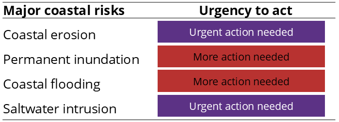
To support the application of the European Climate Risk Assessment (EUCRA) methodology to the coastal areas of the Veneto Region, a custom AI-based tool called COAST-AId was developed (Dal Barco et al., 2025b). This tool facilitated the analysis and synthesis of extensive documentation, enabling a targeted and efficient approach. The methodology involved identifying the most significant risks affecting the region – e.g., coastal erosion, permanent inundation, coastal flooding (Figure 3), saltwater intrusion – assessing their severity across three timeframes (i.e., current, mid-century, and long-term) and evaluating the effectiveness and readiness of existing policies designed to address these risks. The results were rigorously evaluated through active engagement with local stakeholders and subject-matter experts. This collaborative process informed the EUCRA matrix to calculate the urgency to act in the Veneto coastal area, ultimately guiding the refinement of current policies to better mitigate and manage coastal risks.
Defining risk management options
The risk management options for the Veneto Region were derived from a combination of sources, including a scientific literature review, the preliminary document of the Regional Strategy for Climate Change Adaptation (SRACC), insights from the public consultation process conducted within the SRACC, and findings from focus group discussions with core stakeholders. The resulting DRM measures were reviewed, harmonised and systematically categorised using the Peer Review Assessment Framework (PRAF) (Mysiak et al., 2021), and used as a basis for the development of multi-risk pathways.
The Veneto Region’s sectoral plans featured in the SRACC was examined via the COAST-AId tool (Dal Barco et al., 2025b) to assess their effectiveness and level of preparedness, with the goal of guiding their refinement and improvement to address the identified coastal risks effectively. This analysis was achieved by applying the European Climate Risk Assessment (EUCRA) matrix to the coastal area of the Veneto region, incorporating information on risk identification, risk analysis, and policy evaluation. The matrix enabled the categorisation of the urgency to act in the Veneto coastal area (Figure 4).
Venice has significantly reduced flood damages thanks to the MOSE system, yet rising sea levels may challenge its effectiveness in the coming decades, calling for new and long-term adaptation strategies. Meanwhile, coastal erosion continues to reshape the Veneto shoreline, demanding more sustainable and nature-based solutions to preserve its resilience. Without enhanced adaptation efforts, parts of the coast could even face the risk of permanent inundation by the end of the century, while saltwater intrusion is advancing inland, threatening agricultural productivity and underscoring the urgency of protecting soils, water, and livelihoods across the region.
This systemic framework offered decision-makers valuable insights, enabling the optimisation of policies and adaptation strategies tailored to the specific challenges of the Veneto coast.
Accounting for future system state
In the Veneto Region, the future state of multi-hazard footprints was analysed using DBSCAN until the year 2070, under climate change scenarios Representative Concentration Pathways (RCP) 4.5 and 8.5 from the Very High-Resolution Projections over Italy of CMCC. The analysis for future scenarios indicated a shift: under RCP8.5, from 2010 to 2040, precipitation combined with heat, drought, or wind events are projected to dominate, but in the later years (2040-2070), nearly all areas are expected to experience more frequent heat and drought events. For RCP4.5, heat and drought events are prevalent across both time frames due to model projections of extended dry periods beginning around 2030-2040, whereas RCP8.5 shows a marked increase in drought events starting around 2040 (Ferrario et al., 2025b).
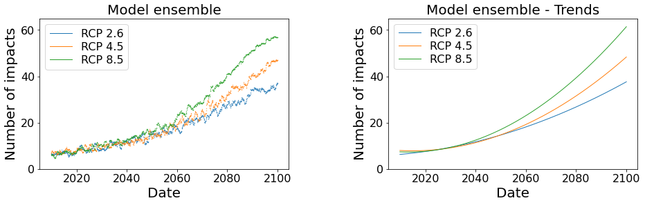
Building upon the work discussed in Dal Barco et al. (2024), a multi-risk assessment combining Multi-Layer Perceptron and Linear Regression models was completed for the Veneto coastal area and for three climate change scenarios (i.e., RCP 2.6, RCP 4.5, and RCP 8.5) until 2100 (Dal Barco et al., 2025a). The analysis indicated that coastal impacts are expected to increase over the century, with notable variations between the different Representative Concentration Pathways (RCP) scenarios (Figure 5). In particular, the lowest number of impacts was projected under the lowest emission scenario (RCP 2.6), with around 35 impacts per year, the mid-emission scenario (RCP 4.5) estimated approximately 50 impacts per year, while the high-emission scenario (RCP 8.5) forecasts up to 60 impacts annually. This divergence between scenarios becomes more pronounced towards the end of the century: starting from 2040, impacts under the RCP 8.5 scenario showed the steepest increase, whereas RCP 2.6 and RCP 4.5 paths diverging around 2060.
Developing multi-risk pathways
The development of multi-risk DRM pathways was grounded in the assessment of DRM capabilities, defined as the ability to reduce, adapt to, or mitigate risks identified in risk assessments to acceptable levels.
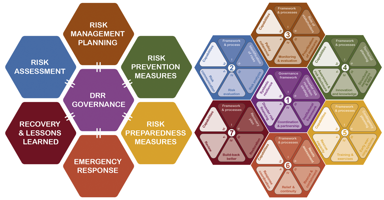
CMCC relied on the Peer Review Assessment Framework (PRAF), developed in the context of the Union Civil Protection Mechanism (UCPM) Peer Review Programme of disaster risk management and civil protection systems. The PRAF covers seven key focus areas: (1) governance of disaster risk reduction, (2) risk assessment, (3) risk management planning, (4) risk prevention, (5) risk preparedness, (6) emergency response, and (7) recovery and lessons learned. Each area is broken down into six sub-topics (wedges in Figure 6).
Originally developed to identify strengths and areas for improvements of countries’ and regions’ DRM systems, the PRAF was used to support the development of two complementary types of pathways for the Veneto Region: general multi-risk DRM pathways and tailored cross-sectoral DRM pathways.
The general multi-risk DRM pathways outline a comprehensive, system-level approach that serves as an integrated basis for long-term resilience planning, without focusing on any particular type of hazard. Hence, the measures outlined within these pathways can be further tailored to address specific hazards.
The tailored cross-sectoral DRM pathways build upon the general ones and are designed to specifically address selected cross-sectoral risks, targeting the following sectors: finance, infrastructure and transport, tourism, ecosystem and forestry, and civil protection. Specifically, these pathways were developed for two cross-sectoral key risks: economic crisis and shortage of economic resources due to a downsizing tourism economy and declining agricultural product (Risk 1) and prolonged interruption of critical infrastructure and inefficient emergency response due to cascading impacts of consecutive disasters (Risk 2) (Gottardo et al, 2025). The key risks were identified by building on the Storylines Vaia 2018 and Vaia 2074, available via the ArcGIS StoryMap tool (Casartelli et al., 2025a; Casartelli et al., under review).
Both pathways and storylines were co-developed with local stakeholders and presented during the Final Pilot Workshop.
References:
- Casartelli, V., Salpina, D., Marengo, A., Mohammadi, S. Vaia 2018 – Plausible Vaia 2074 storm: Storylines for the Veneto pilot. Myriad-EU project. ArcGIS StoryMaps, 2025a. https://doi.org/10.25424/cmcc-b5tt-1×90.
- Casartelli, V., Salpina, D., Marengo, A., Vivo, G., Sørensen, J., Mysiak, J. An innovative framework to conduct peer reviews of disaster risk management capabilities under the Union Civil Protection Mechanism (UCPM). International Journal of Disaster Risk Reduction, 120, 105350, 2025b. https://doi.org/10.1016/j.ijdrr.2025.105350.
- Casartelli, V., Salpina, D., Marengo, A., Ferrario, D.M., Mysiak, J., Torresan, S. Back to the Future: Advancing climate risk assessments with event-based participatory storylines, [Under review – Climate Risk Management].
- Dal Barco, M.K., Casartelli, V., Sanò, M., Vascon, S., Torresan, S., Critto, A. Prioritise risks and improve adaptation strategies in the Veneto coast through the application of a custom AI tool. International Journal of Disaster Risk Reduction, 130, 105818, 2025b. https://doi.org/10.1016/j.ijdrr.2025.105818.
- Dal Barco, M.K., Maraschini, M., Nguyen, N.D., Ferrario, D.M., Rufo, O., Fonseca, H.L., Torresan, S., Vascon, S., & Critto, A. Integrating AI and climate change scenarios for multi-risk assessment in the coastal municipalities of the Veneto region. Science of the Total Environment, 965, 178586, 2025a. https://doi.org/10.1016/j.scitotenv.2025.178586.
- Dal Barco, M.K., Maraschini, M., Ferrario, D.M., Nguyen, N.D., Torresan, S., Vascon, S. & Critto, A. A machine learning approach to evaluate coastal risks related to extreme weather events in the Veneto region (Italy). International Journal of Disaster Risk Reduction, 108, 104526, 2024. https://doi.org/10.1016/j.ijdrr.2024.104526
- Ester, M., Kriegel, H.P., Sander, J. & Xu, X. A density-based algorithm for discovering clusters in large spatial databases with noise. In kdd, Vol. 96, No. 34, pp. 226-231, 1996. https://dl.acm.org/doi/10.5555/3001460.3001507.
- Ferrario, D.M., Sanò, M., Maraschini, M., Critto, A., and Torresan, S. Review article: Harnessing Machine Learning methods for climate multi-hazard and multi-risk assessment, EGUsphere [preprint], 2025a. https://doi.org/10.5194/egusphere-2025-670.
- Ferrario, D.M., Tiggeloven, T., Maraschini, M., Sano, M., Claassen, J., de Ruiter, M.C., Torresan, S., Critto, A. A machine learning methodology to identify current and future multi-hazard extreme events. Environmental Modelling & Software [preprint]. July 31, 2025b. 10.22541/essoar.175396232.24844978/v1.
- Ferrario, D.M., Tiggeloven, T., Casagrande, S., Sanò, M., Torresan, S., Critto, A. A Machine Learning approach for climate multi-risk in the Veneto Region. [In preparation].
- Gottardo, S., Ciurean, R., Daloz, A. S., Padron-Fumero, N., Šakić Trogrlić, R., Tatman, S., Torresan, S., Casartelli, V., Critto, A., Dal Barco, M. K., Díaz- Pacheco, J., Ferrario, D. M., García González, S., Gatti, I., Geurts, D., Hochrainer-Stigler, S., Ma, L., Marengo, A., Romero Manrique Lara, D., … Ward, P. J. (2025). D3.4 Final report on forward-looking DRM pathways and recommendations for upscaling and transferability. Zenodo. https://doi.org/10.5281/zenodo.17245464
- Mysiak, J., Casartelli, V., Torresan, S. Union Civil Protection Mechanism – Peer Review Programme for disaster risk management: Assessment Framework. 2021 https://doi.org/10.25424/CMCC-CHC1-TF40.
- Nguyen, N.D., Furlanetto, J., Torresan, S., Critto, A. Understanding Multi-(Hazard-)Risk Dynamics between Land Use, Climate Extremes and Water Quality leveraging Artificial Intelligence. Ecological Indicators, 182, 114494, 2025. https://doi.org/10.1016/j.ecolind.2025.114494.